IMAGES TAKEN NEAR TO
COLYTON, EX24 6SH
Introduction
This page details the photographs taken nearby to EX24 6SH by members of the Geograph project.
The Geograph project started in 2005 with the aim of publishing, organising and preserving representative images for every square kilometre of Great Britain, Ireland and the Isle of Man.

There are currently over 7.5m images from over14,400 individuals and you can help contribute to the project by visiting https://www.geograph.org.uk
Image Map (Loading...)


Getting Data...Please wait
Leaflet Map data © OpenStreetMap
Images are licensed for reuse under creativecommons.org/licenses/by-sa/2.0
Notes
- Clicking on the map will re-center to the selected point.
- The higher the marker number, the further away the image location is from the centre of the postcode.
Image Listing (7 Images Found)
Images are licensed for reuse under creativecommons.org/licenses/by-sa/2.0
Image
Details
Distance
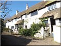
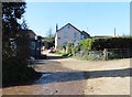
3
Near Streathayne House
Looking SW from the road.
Image: © T Eyre
Taken: 13 Sep 2018
0.08 miles
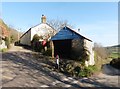
6
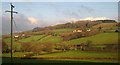
Across the Coly valley
Taken from the same point as Image On the right up the hill is Hooperhayne, a farm with three listed buildings http://tinyurl.com/co2rnpc . To the left is Streathayne http://list.english-heritage.org.uk/resultsingle.aspx?uid=1098564&searchtype=mapsearch . Above is Carswell Moor.
Image: © Derek Harper
Taken: 5 Dec 2012
0.21 miles
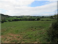
7
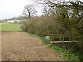
Footbridge for East Devon Way near Streathayne
Streathayne is in the distance, by the road that runs parallel to the river. The electric fence has been lifted to give walkers a safe crossing through the bridge. The notice advises that the path has been slightly diverted and runs closer to the river.
Image: © David Smith
Taken: 13 Apr 2015
0.25 miles