IMAGES TAKEN NEAR TO
COLYTON, EX24 6SF
Introduction
This page details the photographs taken nearby to EX24 6SF by members of the Geograph project.
The Geograph project started in 2005 with the aim of publishing, organising and preserving representative images for every square kilometre of Great Britain, Ireland and the Isle of Man.

There are currently over 7.5m images from over14,400 individuals and you can help contribute to the project by visiting https://www.geograph.org.uk
Image Map
Images are licensed for reuse under creativecommons.org/licenses/by-sa/2.0
Notes
- Clicking on the map will re-center to the selected point.
- The higher the marker number, the further away the image location is from the centre of the postcode.
Image Listing (17 Images Found)
Images are licensed for reuse under creativecommons.org/licenses/by-sa/2.0
Image
Details
Distance
1
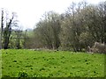
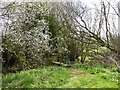
Trees beside the confluence of Offwell Brook and River Coly
The Coly flows from right to left, and is joined by the Offwell Brook, flowing past the trees on the right
Image: © David Smith
Taken: 13 Apr 2015
0.11 miles
2
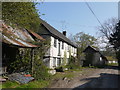
Cottages at Purlbridge Farm
Old unrenovated cottages that incorporate old working buildings associated with the farm.
Image: © Nigel Mykura
Taken: 7 May 2016
0.13 miles
3
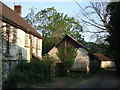
Purlbridge Farm
A farm in the Coly valley that seems to have been overlooked by the passage of time. On Purlbridge Road approaching Bonehayne.
Image: © Derek Harper
Taken: 2 May 2007
0.14 miles
4
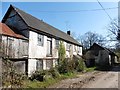
Dilapidated house at Purlbridge Farm
Rare these days to see an 'unimproved' dwelling in rural Devon.
Image: © Roger Cornfoot
Taken: 23 Mar 2020
0.15 miles
5
Footbridge on East Devon Way near Hamberhayne Farm
A small bridge over a drainage ditch or stream beside the River Coly (beyond the trees to the right)
Image: © David Smith
Taken: 13 Apr 2015
0.15 miles
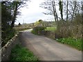
6
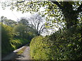
Blackacre Road
This small little used rural lane runs up to Pookhayne from Purlbridge on the north side of Knowle Hill.
Image: © Nigel Mykura
Taken: 7 May 2016
0.17 miles
7
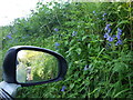
Bluebells on the Bank
Driving along Blackacre Rd means being very close to the sides of the lane because it is so narrow but it does mean one gets a close look at the flora, and with a wing mirror, in both directions.
Image: © Nigel Mykura
Taken: 7 May 2016
0.17 miles
8
East Devon Way near Hamberhayne
The long distance footpath runs beside the Offwell Brook to this kissing gate, joins the road, and crosses the stream.
Image: © David Smith
Taken: 13 Apr 2015
0.19 miles
9
Bridge over Offwell Brook near Hamberhayne Farm
Image: © David Smith
Taken: 13 Apr 2015
0.19 miles
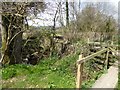
10
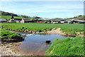
Ford by Bonehayne
Looking across the River Coly from the East Devon Way towards the farmhouse and outbuildings of Bonehayne.
Image: © Trevor Harris
Taken: 15 Apr 2014
0.19 miles