IMAGES TAKEN NEAR TO
Southleigh, COLYTON, EX24 6JA
Introduction
This page details the photographs taken nearby to EX24 6JA by members of the Geograph project.
The Geograph project started in 2005 with the aim of publishing, organising and preserving representative images for every square kilometre of Great Britain, Ireland and the Isle of Man.

There are currently over 7.5m images from over14,400 individuals and you can help contribute to the project by visiting https://www.geograph.org.uk
Image Map
Images are licensed for reuse under creativecommons.org/licenses/by-sa/2.0
Notes
- Clicking on the map will re-center to the selected point.
- The higher the marker number, the further away the image location is from the centre of the postcode.
Image Listing (6 Images Found)
Images are licensed for reuse under creativecommons.org/licenses/by-sa/2.0
Image
Details
Distance
1
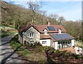
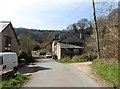
Stockham, Devon
This is about 2 miles north of Hangmans Stone on the A35. Lots of building work was taking place when the photo was taken.
Image: © Stuart Buchan
Taken: 10 May 2006
0.18 miles
2
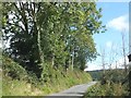
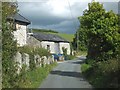
Stockham
The view shown in Image, but on a gloomy winter's day rather than a sunny spring one; in fact, it's starting to rain quite heavily. The lane is from Hangman's Stone to Southleigh, along the southeast slopes of Southleigh Hill.
Image: © Derek Harper
Taken: 21 Jan 2012
0.23 miles
4
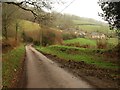
Stone barn beside road at Stockham Farm
Image: © David Smith
Taken: 25 Sep 2012
0.23 miles