IMAGES TAKEN NEAR TO
Thornfield Close, EX24 6AL
Introduction
This page details the photographs taken nearby to Thornfield Close, EX24 6AL by members of the Geograph project.
The Geograph project started in 2005 with the aim of publishing, organising and preserving representative images for every square kilometre of Great Britain, Ireland and the Isle of Man.

There are currently over 7.5m images from over14,400 individuals and you can help contribute to the project by visiting https://www.geograph.org.uk
Image Map
Images are licensed for reuse under creativecommons.org/licenses/by-sa/2.0
Notes
- Clicking on the map will re-center to the selected point.
- The higher the marker number, the further away the image location is from the centre of the postcode.
Image Listing (12 Images Found)
Images are licensed for reuse under creativecommons.org/licenses/by-sa/2.0
Image
Details
Distance
1
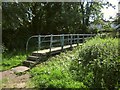
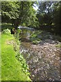
Footbridge across the Coly
Colyton Footpath 7 crosses this footbridge to meet the B3161 at the southern end of Colyton; meanwhile Colyton Footpath 27 turns away and continues along the left bank of the river. A bank of nettles on the right.
Image: © Derek Harper
Taken: 19 Jun 2012
0.02 miles

3

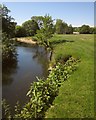
The River Coly
A short section that has not been colonised by Himalayan Balsam or Japanese Knotweed though there are extensive areas of both nearby.
Image: © Jonathan Thacker
Taken: 5 Sep 2014
0.04 miles
4

Path by the Coly
The river is only a few metres to the right of Colyton Footpath 7 as it heads down the left bank, but can't be seen here for trees and bushes.
Image: © Derek Harper
Taken: 19 Jun 2012
0.10 miles
5
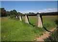
Pipeline by the Coly
A pipeline crossing the water meadow east of the river, and Colyton Footpath 27.
Image: © Derek Harper
Taken: 19 Jun 2012
0.13 miles
6
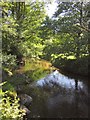
River Coly
Looking downstream, with the river flowing beneath trees. It is diminished in volume here because a mill race for Cole's Mill runs in parallel, away to the right.
Image: © Derek Harper
Taken: 19 Jun 2012
0.16 miles
7

River Coly
Taken at a footpath junction where the East Devon Way veers away from the river, while Colyton Footpath 7 continues alongside it. See also Image
Image: © Derek Harper
Taken: 19 Jun 2012
0.18 miles
8
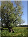
Willow by the Coly
Its branches can be seen on the left of Image Here the East Devon Way veers away from the river along Colyton Footpath 25, while Colyton Footpath 7 continues alongside it.
Image: © Derek Harper
Taken: 19 Jun 2012
0.20 miles
9
River Coly
On the East Devon Way and Colyton Footpath 7, running beside the river along water meadows towards Image A dingle slip-off slope is just upstream, I the foreground, Himalayan balsam is starting to take over.
Image: © Derek Harper
Taken: 19 Jun 2012
0.22 miles
10
River Coly
Looking downstream from close to the spot where Image was taken, with a shallow stretch of river.
Image: © Derek Harper
Taken: 19 Jun 2012
0.22 miles