IMAGES TAKEN NEAR TO
Hersham, BUDE, EX23 9NA
Introduction
This page details the photographs taken nearby to EX23 9NA by members of the Geograph project.
The Geograph project started in 2005 with the aim of publishing, organising and preserving representative images for every square kilometre of Great Britain, Ireland and the Isle of Man.

There are currently over 7.5m images from over14,400 individuals and you can help contribute to the project by visiting https://www.geograph.org.uk
Image Map
Images are licensed for reuse under creativecommons.org/licenses/by-sa/2.0
Notes
- Clicking on the map will re-center to the selected point.
- The higher the marker number, the further away the image location is from the centre of the postcode.
Image Listing (8 Images Found)
Images are licensed for reuse under creativecommons.org/licenses/by-sa/2.0
Image
Details
Distance
1
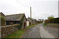
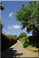
Houses near Hersham
This lane runs to Stratton.
Image: © Julian P Guffogg
Taken: 8 Apr 2012
0.07 miles
2
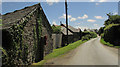
Houses, Hersham
At Little Bidna. On the left is Elizabeth II postbox EX23 89.
Image: © Derek Harper
Taken: 21 Jun 2019
0.07 miles
3
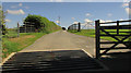
Farm road to Bidna Lodge
On the other side of the lane from the gateway where Image] and Image] were taken. Not a right of way.
Image: © Derek Harper
Taken: 21 Jun 2019
0.08 miles
4
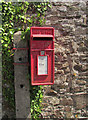
Postbox, Hersham
Elizabeth II postbox EX23 89, at Little Bidna, is visible in Image
Image: © Derek Harper
Taken: 21 Jun 2019
0.08 miles
5
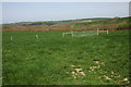
Farmland at Hersham
View to the north from the road on the western side of the small village.
Image: © Philip Halling
Taken: 17 Apr 2007
0.09 miles
7
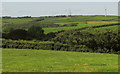
Farmland west of Hersham
From the lane southwest of the village, looking across the headwater valley of a tributary of the Strat. The right-hand turbine is near Collaton Farm, in Image
Image: © Derek Harper
Taken: 21 Jun 2019
0.14 miles
8
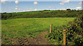
Farmland near Hersham
Looking right from Image
Image: © Derek Harper
Taken: 21 Jun 2019
0.18 miles