IMAGES TAKEN NEAR TO
Upton, BUDE, EX23 0LY
Introduction
This page details the photographs taken nearby to EX23 0LY by members of the Geograph project.
The Geograph project started in 2005 with the aim of publishing, organising and preserving representative images for every square kilometre of Great Britain, Ireland and the Isle of Man.

There are currently over 7.5m images from over14,400 individuals and you can help contribute to the project by visiting https://www.geograph.org.uk
Image Map
Images are licensed for reuse under creativecommons.org/licenses/by-sa/2.0
Notes
- Clicking on the map will re-center to the selected point.
- The higher the marker number, the further away the image location is from the centre of the postcode.
Image Listing (63 Images Found)
Images are licensed for reuse under creativecommons.org/licenses/by-sa/2.0
Image
Details
Distance
1

Looking across Marine Drive
Looking across Marine Drive to County Road at Upton
Image: © Shaun Ferguson
Taken: 31 Aug 2012
0.05 miles
2
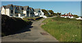
Houses and flats at Upton
From Upton Cross, looking along County Road. Eleven flats occupy Piran Heights on the left.
Image: © Derek Harper
Taken: 21 Jun 2019
0.06 miles
3
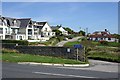
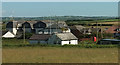
Upton
Upton is a small settlement of private houses and guest houses strung out along a minor road which runs inland and downhill from the coast road.
Image: © Tony Atkin
Taken: 11 Sep 2009
0.08 miles
5

Cornish Flag at Upton
The Cornish flag is very distinctive and is flown a lot.
Oxfordshire, where we live, has quite a nice blue flag but you hardly ever see it.
Image: © Des Blenkinsopp
Taken: 26 May 2021
0.10 miles
6

Coast Path Diversion
Subsidence along the cliff edge has meant that the Coast Path has had to be diverted inland onto a roadside section for a short distance.
Fortunately there is a pavement by these few houses so no safety problems. The path heads back to the coast just by where the people are.
Image: © Des Blenkinsopp
Taken: 26 May 2021
0.10 miles
7
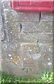
Ordnance Survey Cut Mark
This OS cut mark can be found next to the letter box. It marks a point 45.976m above mean sea level.
Image: © Adrian Dust
Taken: 24 Feb 2017
0.11 miles
8
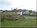
A seat by the path and road at Upton
One of several seat by the South West Coast Path here; beyond are houses and other buildings at Upton
Image: © David Smith
Taken: 15 Apr 2016
0.11 miles
9
Houses at Upton
The nearest building is mapped as a "rescue equipment house". Image] looks right from the same spot.
Image: © Derek Harper
Taken: 21 Jun 2019
0.11 miles
10
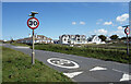
30 mph into Upton
Along the coast road into Bude from the south.
Image: © Des Blenkinsopp
Taken: 26 May 2021
0.11 miles