IMAGES TAKEN NEAR TO
Titson, BUDE, EX23 0HQ
Introduction
This page details the photographs taken nearby to Titson, EX23 0HQ by members of the Geograph project.
The Geograph project started in 2005 with the aim of publishing, organising and preserving representative images for every square kilometre of Great Britain, Ireland and the Isle of Man.

There are currently over 7.5m images from over14,400 individuals and you can help contribute to the project by visiting https://www.geograph.org.uk
Image Map
Images are licensed for reuse under creativecommons.org/licenses/by-sa/2.0
Notes
- Clicking on the map will re-center to the selected point.
- The higher the marker number, the further away the image location is from the centre of the postcode.
Image Listing (7 Images Found)
Images are licensed for reuse under creativecommons.org/licenses/by-sa/2.0
Image
Details
Distance
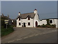
2
Houses and phone box, Titson
Titson is a tiny village with just a few houses around the road junction.
Image: © David Hawgood
Taken: 16 Apr 2007
0.01 miles
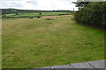
3
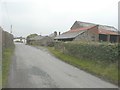
Titson Farm
Beside the lane through the hamlet.
Image: © John Baker
Taken: 24 Mar 2013
0.04 miles
4
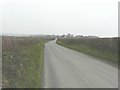
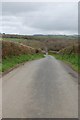
A distant view of Titson
Along the lane leading to the hamlet from the east, on a gloomy late March day.
Image: © John Baker
Taken: 24 Mar 2013
0.06 miles
5
Track of old railway line
Taken from a bridge at Titson, all trace of the line has been eliminated here.
Image: © Julian P Guffogg
Taken: 11 Aug 2013
0.07 miles
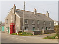
6
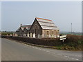
Former Methodist chapel, Titson
This chapel has been converted to a dwelling house. A peculiarity of the site is that the churchyard surrounds the house on three sides, but is separate from it, and seems to be open to the public.
Image: © David Hawgood
Taken: 16 Apr 2007
0.10 miles