IMAGES TAKEN NEAR TO
Marhamchurch, BUDE, EX23 0EP
Introduction
This page details the photographs taken nearby to EX23 0EP by members of the Geograph project.
The Geograph project started in 2005 with the aim of publishing, organising and preserving representative images for every square kilometre of Great Britain, Ireland and the Isle of Man.

There are currently over 7.5m images from over14,400 individuals and you can help contribute to the project by visiting https://www.geograph.org.uk
Image Map
Images are licensed for reuse under creativecommons.org/licenses/by-sa/2.0
Notes
- Clicking on the map will re-center to the selected point.
- The higher the marker number, the further away the image location is from the centre of the postcode.
Image Listing (43 Images Found)
Images are licensed for reuse under creativecommons.org/licenses/by-sa/2.0
Image
Details
Distance
1
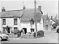
Cottages on the corner, Marhamchurch, 1966
On the corner of Helebridge Road and Pinch Hill (on the right).
Image: © Robin Webster
Taken: Unknown
0.01 miles
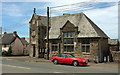
2
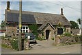
Former National School, Marhamchurch
Bearing the date 1873 on the lintel.
Image: © Derek Harper
Taken: 31 May 2016
0.01 miles
3

Marhamchurch war memorial, 1966
Beyond is the church institute, with the church behind the viewpoint. 265 KAF is a Cornish registration.
Image: © Robin Webster
Taken: Unknown
0.01 miles
4

The top of Pinch Hill
Where it enters Helebridge Road.
Image: © John Baker
Taken: 24 Mar 2013
0.01 miles
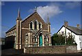
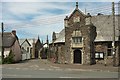
5
"The Bray" Church of England Institute, Marhamchurch
Image: © Julian P Guffogg
Taken: 3 Aug 2009
0.02 miles
6

Marhamchurch war memorial
The names for WW1 appear to have been listed alphabetically in two or three parts, starting with one man from RN Devon Hussars, then three from the Duke of Cornwall's Light Infantry, then those who served in other units
Image: © David Smith
Taken: 14 Apr 2016
0.02 miles
7

Marhamchurch war memorial (WW2 side)
The names on the memorial are in alphabetical order
Image: © David Smith
Taken: 14 Apr 2016
0.02 miles
8
Top of Pinch Hill, Marhamchurch
On the right is Image] https://www.historicengland.org.uk/listing/the-list/list-entry/1141805 , on the left Rosamund Cottage https://www.historicengland.org.uk/listing/the-list/list-entry/1278402 , and down the hill is the Methodist Church Image, with its hall on this side.
Image: © Derek Harper
Taken: 31 May 2016
0.02 miles
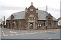
9
Church of England Institute, Marhamchurch
Also shown in Image Described at https://www.historicengland.org.uk/listing/the-list/list-entry/1141805 as "Arts and Crafts, free Tudor style", the building, with its "grand 2-storey gabled corner porch", is listed. The thatched cottage on the left is also listed https://www.historicengland.org.uk/listing/the-list/list-entry/1278402 .
Image: © Derek Harper
Taken: 31 May 2016
0.02 miles