IMAGES TAKEN NEAR TO
Jacobstow, BUDE, EX23 0BU
Introduction
This page details the photographs taken nearby to EX23 0BU by members of the Geograph project.
The Geograph project started in 2005 with the aim of publishing, organising and preserving representative images for every square kilometre of Great Britain, Ireland and the Isle of Man.

There are currently over 7.5m images from over14,400 individuals and you can help contribute to the project by visiting https://www.geograph.org.uk
Image Map
Images are licensed for reuse under creativecommons.org/licenses/by-sa/2.0
Notes
- Clicking on the map will re-center to the selected point.
- The higher the marker number, the further away the image location is from the centre of the postcode.
Image Listing (4 Images Found)
Images are licensed for reuse under creativecommons.org/licenses/by-sa/2.0
Image
Details
Distance
1
Tobarn farm buildings
Long low buildings viewed from the road.
Image: © David Hawgood
Taken: 27 Feb 2008
0.07 miles
2
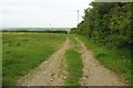
Track by South Headon
The (private) track starts from close to the camera position in Image
Image: © Derek Harper
Taken: 31 May 2016
0.20 miles
3
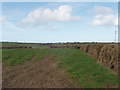
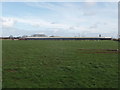
Fields near Tobarn and Wainhouse Corner
The buildings on the skyline are by the A39 main road. View from road which is one branch of National Cycle Route no 3.
Image: © David Hawgood
Taken: 27 Feb 2008
0.20 miles
4
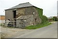
Barn, South Headon
By the road from Jacobstow to Headon Cross.
Image: © Derek Harper
Taken: 31 May 2016
0.23 miles