IMAGES TAKEN NEAR TO
Bradworthy, HOLSWORTHY, EX22 7RX
Introduction
This page details the photographs taken nearby to EX22 7RX by members of the Geograph project.
The Geograph project started in 2005 with the aim of publishing, organising and preserving representative images for every square kilometre of Great Britain, Ireland and the Isle of Man.

There are currently over 7.5m images from over14,400 individuals and you can help contribute to the project by visiting https://www.geograph.org.uk
Image Map (Loading...)


Getting Data...Please wait
Leaflet Map data © OpenStreetMap
Images are licensed for reuse under creativecommons.org/licenses/by-sa/2.0
Notes
- Clicking on the map will re-center to the selected point.
- The higher the marker number, the further away the image location is from the centre of the postcode.
Image Listing (4 Images Found)
Images are licensed for reuse under creativecommons.org/licenses/by-sa/2.0
Image
Details
Distance
2

The River Waldon
The River Waldon to the west of Bradworthy.
Image: © Philip Halling
Taken: 17 Apr 2007
0.07 miles
3
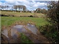
Field near Bradworthy
A similar view to Image across the same puddles. This scene has a different backdrop, with houses on the climb out of Bradworthy, on the lane to Berridon, again in Image
Image: © Derek Harper
Taken: 27 Mar 2008
0.16 miles
4
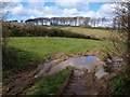
Field near Bradworthy
Looking through a damp gateway from the lane from Bradworthy to Stowford. The fine beeches are on the lane past Berridon Hall, and, like the intervening valley (of a tributary of the Waldon), are in SS3114.
Image: © Derek Harper
Taken: 27 Mar 2008
0.17 miles