IMAGES TAKEN NEAR TO
Sutcombe, HOLSWORTHY, EX22 7QP
Introduction
This page details the photographs taken nearby to EX22 7QP by members of the Geograph project.
The Geograph project started in 2005 with the aim of publishing, organising and preserving representative images for every square kilometre of Great Britain, Ireland and the Isle of Man.

There are currently over 7.5m images from over14,400 individuals and you can help contribute to the project by visiting https://www.geograph.org.uk
Image Map
Images are licensed for reuse under creativecommons.org/licenses/by-sa/2.0
Notes
- Clicking on the map will re-center to the selected point.
- The higher the marker number, the further away the image location is from the centre of the postcode.
Image Listing (1 Images Found)
Images are licensed for reuse under creativecommons.org/licenses/by-sa/2.0
Image
Details
Distance
1
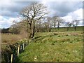
Fields at Youldon
Trees and thin belts of woodland follow the lines of watercourses which form a tributary of the River Waldon. Satellite images show that mature trees used to follow the drain on the left right up to the lane to Youldon Farm (followed by Abbots Bickington Footpath 3) from where this image was taken.
Image: © Derek Harper
Taken: 27 Mar 2008
0.13 miles