IMAGES TAKEN NEAR TO
Pancrasweek, HOLSWORTHY, EX22 7JZ
Introduction
This page details the photographs taken nearby to EX22 7JZ by members of the Geograph project.
The Geograph project started in 2005 with the aim of publishing, organising and preserving representative images for every square kilometre of Great Britain, Ireland and the Isle of Man.

There are currently over 7.5m images from over14,400 individuals and you can help contribute to the project by visiting https://www.geograph.org.uk
Image Map (Loading...)


Getting Data...Please wait
Leaflet Map data © OpenStreetMap
Images are licensed for reuse under creativecommons.org/licenses/by-sa/2.0
Notes
- Clicking on the map will re-center to the selected point.
- The higher the marker number, the further away the image location is from the centre of the postcode.
Image Listing (9 Images Found)
Images are licensed for reuse under creativecommons.org/licenses/by-sa/2.0
Image
Details
Distance
1
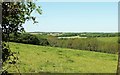
Tamar valley from near Broomhill Cross
Looking to the left across the field shown in Image], across the Bude Aqueduct and the valley towards Lower Pigsdon Farm, in Image
Image: © Derek Harper
Taken: 31 May 2016
0.10 miles
2
Tamar valley from near Broomhill Cross
From the lane to Dexbeer. The first line of trees across the image marks the course of the Bude Aqueduct. The farm building is at Higher Dexbeer Farm in Image See also Image
Image: © Derek Harper
Taken: 31 May 2016
0.19 miles
3
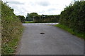
Road junction at Broomhill
Bude is 6 miles to the right.
Image: © Julian P Guffogg
Taken: 11 Aug 2013
0.19 miles
4
Broomhill Cross
Another T junction of lanes - there are a lot around here. To the right is Dexbeer ½ and Thurdon 1½.
Image: © Derek Harper
Taken: 31 May 2016
0.19 miles
5
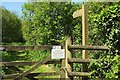
Path along Bude Aqueduct
Looking right from Dexbeer Bridge, shown in Image], along Pancrasweek Footpath 3 on the Aqueduct Trail alongside the former Bude Canal.
Image: © Derek Harper
Taken: 31 May 2016
0.22 miles
6
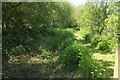
Bude Aqueduct
Like Image], looking along Pancrasweek Footpath 3 from Dexbeer Bridge.
Image: © Derek Harper
Taken: 31 May 2016
0.23 miles
7
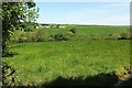
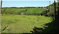
Field above the Bude Aqueduct
Looking to the left from the same spot as Image], more directly across the aqueduct and the Tamar valley, with Lower Dexbeer Farm in Image
Image: © Derek Harper
Taken: 31 May 2016
0.23 miles
8
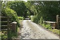
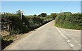
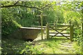
Dexbeer Bridge
The lane between Dexbeer and Broomhill Cross bridges the Bude Aqueduct, the former canal.
Image: © Derek Harper
Taken: 31 May 2016
0.24 miles
9
Dexbeer Bridge
Pancrasweek Footpath 3 following the Bude Aqueduct as it approaches the bridge shown in Image
Image: © Derek Harper
Taken: 31 May 2016
0.24 miles