IMAGES TAKEN NEAR TO
Fore Street, HOLSWORTHY, EX22 7AJ
Introduction
This page details the photographs taken nearby to Fore Street, EX22 7AJ by members of the Geograph project.
The Geograph project started in 2005 with the aim of publishing, organising and preserving representative images for every square kilometre of Great Britain, Ireland and the Isle of Man.

There are currently over 7.5m images from over14,400 individuals and you can help contribute to the project by visiting https://www.geograph.org.uk
Image Map
Images are licensed for reuse under creativecommons.org/licenses/by-sa/2.0
Notes
- Clicking on the map will re-center to the selected point.
- The higher the marker number, the further away the image location is from the centre of the postcode.
Image Listing (2 Images Found)
Images are licensed for reuse under creativecommons.org/licenses/by-sa/2.0
Image
Details
Distance
1
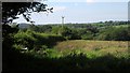
Field above the Torridge valley
From the same gate as Image], looking to the left with a little overlap.
Image: © Derek Harper
Taken: 31 May 2014
0.17 miles
2
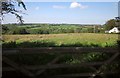
Field above the Torridge valley
Seen from Fore Street, the road carrying NCN3 between Holemoor and Dippermill.
Image: © Derek Harper
Taken: 31 May 2014
0.17 miles