IMAGES TAKEN NEAR TO
Horslett Hill, HOLSWORTHY, EX22 6RS
Introduction
This page details the photographs taken nearby to Horslett Hill, EX22 6RS by members of the Geograph project.
The Geograph project started in 2005 with the aim of publishing, organising and preserving representative images for every square kilometre of Great Britain, Ireland and the Isle of Man.

There are currently over 7.5m images from over14,400 individuals and you can help contribute to the project by visiting https://www.geograph.org.uk
Image Map
Images are licensed for reuse under creativecommons.org/licenses/by-sa/2.0
Notes
- Clicking on the map will re-center to the selected point.
- The higher the marker number, the further away the image location is from the centre of the postcode.
Image Listing (4 Images Found)
Images are licensed for reuse under creativecommons.org/licenses/by-sa/2.0
Image
Details
Distance
1
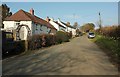
Hawkes Place
Houses on Horslett Hill; the lane is climbing steadily from the Deer valley.
Image: © Derek Harper
Taken: 15 Mar 2016
0.01 miles
2
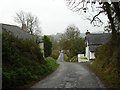
Road to North Tamerton
View west southwest. Cornwall lies at the bottom of this hill.
Image: © Robert Walden
Taken: 27 Oct 2007
0.08 miles
3
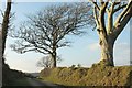
Farm lane to Higher Horslett
The private farm road seen from its junction with the lane up Horslett Hill, and with attractive beeches on the bank.
Image: © Derek Harper
Taken: 15 Mar 2016
0.23 miles
4
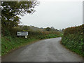
West of Deer Bridge
The Cornwall-Devon border follows the River Deer, which joins the Tamar immediately below Deer Bridge.
Image: © Robert Walden
Taken: 27 Oct 2007
0.23 miles