IMAGES TAKEN NEAR TO
Western Side, HOLSWORTHY, EX22 6RR
Introduction
This page details the photographs taken nearby to Western Side, EX22 6RR by members of the Geograph project.
The Geograph project started in 2005 with the aim of publishing, organising and preserving representative images for every square kilometre of Great Britain, Ireland and the Isle of Man.

There are currently over 7.5m images from over14,400 individuals and you can help contribute to the project by visiting https://www.geograph.org.uk
Image Map
Images are licensed for reuse under creativecommons.org/licenses/by-sa/2.0
Notes
- Clicking on the map will re-center to the selected point.
- The higher the marker number, the further away the image location is from the centre of the postcode.
Image Listing (4 Images Found)
Images are licensed for reuse under creativecommons.org/licenses/by-sa/2.0
Image
Details
Distance
1
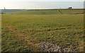
Farmland at Circuit House
A cross-grid from the lane shown in Image, looking across a side valley of the Deer.
Image: © Derek Harper
Taken: 15 Mar 2016
0.07 miles
2
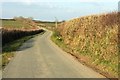
Lane near Layhay
The lane from North Tamerton to Affaland Cross briefly crosses the square; by the time it reaches the junction ahead on the right, the turn into the farm at Fernhill, it has crossed into Image
Image: © Derek Harper
Taken: 15 Mar 2016
0.08 miles
3
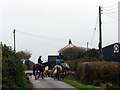
The Hunt near Higher Horslett
Looking south southwest.
Image: © Robert Walden
Taken: 27 Oct 2007
0.11 miles
4
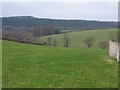
Towards the Deer valley
The tops of trees appear in a side valley, as fields descend towards the Deer. Seen from the lane from Corfcott Green to Deer Bridge.
Image: © Derek Harper
Taken: 8 Feb 2008
0.19 miles