IMAGES TAKEN NEAR TO
Staddon Road, HOLSWORTHY, EX22 6NH
Introduction
This page details the photographs taken nearby to Staddon Road, EX22 6NH by members of the Geograph project.
The Geograph project started in 2005 with the aim of publishing, organising and preserving representative images for every square kilometre of Great Britain, Ireland and the Isle of Man.

There are currently over 7.5m images from over14,400 individuals and you can help contribute to the project by visiting https://www.geograph.org.uk
Image Map
Images are licensed for reuse under creativecommons.org/licenses/by-sa/2.0
Notes
- Clicking on the map will re-center to the selected point.
- The higher the marker number, the further away the image location is from the centre of the postcode.
Image Listing (5 Images Found)
Images are licensed for reuse under creativecommons.org/licenses/by-sa/2.0
Image
Details
Distance
1
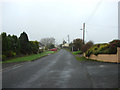
Whimble village
Looking west southwest.
Image: © Robert Walden
Taken: 27 Oct 2007
0.07 miles
2
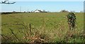
Field and house by Staddon Road
An assortment of houses has sprung up along the road, not quite constituting ribbon development, as this photo (looking left from the spot shown in Image]) shows; the road is behind the hedge on the left and there is a substantial gap here between buildings.
Image: © Derek Harper
Taken: 23 Apr 2016
0.07 miles
3
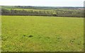
Field by Staddon Road
Looking to the left from the same spot as Image over farmland southeast of Holsworthy.
Image: © Derek Harper
Taken: 23 Apr 2016
0.10 miles
4
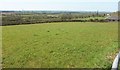
Field by Staddon Road
A field at Shorston, with a view towards the Deer valley south of Holsworthy, with a fairly recent bungalow on the right.
Image: © Derek Harper
Taken: 23 Apr 2016
0.14 miles
5
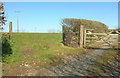
Field and farm track, Staddon
The private track leads from Staddon Road to Southcoombe Road.
Image: © Derek Harper
Taken: 23 Apr 2016
0.17 miles