IMAGES TAKEN NEAR TO
Victoria Hill, HOLSWORTHY, EX22 6JB
Introduction
This page details the photographs taken nearby to Victoria Hill, EX22 6JB by members of the Geograph project.
The Geograph project started in 2005 with the aim of publishing, organising and preserving representative images for every square kilometre of Great Britain, Ireland and the Isle of Man.

There are currently over 7.5m images from over14,400 individuals and you can help contribute to the project by visiting https://www.geograph.org.uk
Image Map
Images are licensed for reuse under creativecommons.org/licenses/by-sa/2.0
Notes
- Clicking on the map will re-center to the selected point.
- The higher the marker number, the further away the image location is from the centre of the postcode.
Image Listing (66 Images Found)
Images are licensed for reuse under creativecommons.org/licenses/by-sa/2.0
Image
Details
Distance
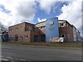
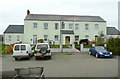
2

Texaco filling station and Spar shop, A3072, Holsworthy
Image: © David Smith
Taken: 14 Apr 2016
0.05 miles
3

Holsworthy Community College and its footbridge
The footbridge crosses the A3072
Image: © David Smith
Taken: 14 Apr 2016
0.05 miles
4

Texaco filling station, Holsworthy
Shown from the opposite side, and just over a week earlier, in Image The tower of the church peeps above the trees.
Image: © Derek Harper
Taken: 23 Apr 2016
0.06 miles
5

Holsworthy : Rydon Road
Looking along Rydon Road as it heads through Holsworthy.
Image: © Lewis Clarke
Taken: 17 Jul 2014
0.06 miles
6
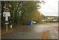
Well Park car park, Holsworthy
With 92 spaces. According to the internet, it costs a flat daily rate of £1, and £32 a month. Err...
Image: © Derek Harper
Taken: 3 Nov 2012
0.07 miles
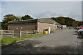
8

House adjoining the Holsworthy Union Workhouse
This is in a later style than the workhouse building, of red brick with yellow brick dressings, and was perhaps the manager's house.
Image: © Humphrey Bolton
Taken: 6 Apr 2010
0.09 miles
9
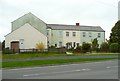
The Holsworthy Union Workhouse
Built in 1857, and became the Dawfield Hospital. The building is T-shaped, and this view includes the north wing (the stalk of the T).
Image: © Humphrey Bolton
Taken: 6 Apr 2010
0.09 miles
10
The Holsworthy Union Workhouse
Built in 1857, and became the Dawfield Hospital. Now flats and houses. The Holsworthy Poor Law Union included a large number of the surrounding civil parishes. PLUs were abolished in 1930 and their functions transferred to the county councils.
Image: © Humphrey Bolton
Taken: 6 Apr 2010
0.09 miles