IMAGES TAKEN NEAR TO
Pine View Close, BEAWORTHY, EX21 5XL
Introduction
This page details the photographs taken nearby to Pine View Close, EX21 5XL by members of the Geograph project.
The Geograph project started in 2005 with the aim of publishing, organising and preserving representative images for every square kilometre of Great Britain, Ireland and the Isle of Man.

There are currently over 7.5m images from over14,400 individuals and you can help contribute to the project by visiting https://www.geograph.org.uk
Image Map
Images are licensed for reuse under creativecommons.org/licenses/by-sa/2.0
Notes
- Clicking on the map will re-center to the selected point.
- The higher the marker number, the further away the image location is from the centre of the postcode.
Image Listing (31 Images Found)
Images are licensed for reuse under creativecommons.org/licenses/by-sa/2.0
Image
Details
Distance
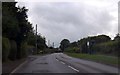
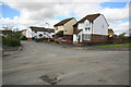
2
Beeching Close, Halwill Junction
Named by someone with an ironic sense of humour; the modern estate is built close to the site of Halwill Junction station and Dr. Beeching was responsible for the closure of passenger services in 1966.
Image: © Derek Harper
Taken: 6 Jul 2007
0.09 miles
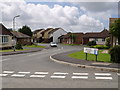
3
Beeching Close
Inevitably named after the closure of all the railway lines through Halwill Junction following the Beeching Report.
Image: © Jonathan Thacker
Taken: 18 Sep 2017
0.10 miles
4
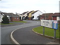
Beeching Close at Halwill Junction
Named after the man who was responsible for the closing of the railway here in the 1960s.
Image: © Rod Allday
Taken: 24 Feb 2013
0.10 miles
5
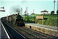
Halwill for Beaworthy Station, 1964
More commonly known as Halwill Junction, a name which still applies to the settlement which grew up round the station.
Passing through is a substantial mixed freight train, probably coming from the North Cornwall line rather than Bude, and headed by an N Class 2-6-0 locomotive. This was a versatile class, at home with both freight and passenger work, and could be found throughout the former Southern Railway territory. The lines through Halwill were all victims of the Beeching era cuts, closing in 1966.
My viewpoint is just in front of the bay window of the house in this view https://www.geograph.org.uk/photo/5541627 - times and the scenery have changed more than a little.
Image: © Alan Murray-Rust
Taken: Unknown
0.10 miles
6
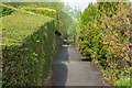
Start of path to Halwill Moor Plantation
The path follows the line of the dismantled railway.
Image: © Guy Wareham
Taken: 12 May 2016
0.10 miles
7
The end of Beeching Close
The last railway links to Halwill Junction were lost when Dr Beeching cut many rural lines in the 1960s. This name is a reminder of the loss.
Image: © David Smith
Taken: 11 May 2012
0.11 miles
8
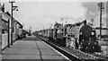
Halwill Junction station, with Up freight
View northward, towards Wadebridge and Padstow on the ex-LSW North Cornwall line, also the branches to Bude and to Torrington. The train is headed for Okehampton and Exeter, hauled by SR Maunsell N class 2-6-0 No. 31845 (built 9/24, withdrawn 9/64).
Image: © Ben Brooksbank
Taken: 17 Apr 1964
0.12 miles
9
Station Fields, once the railway station
One would never know that the LSWR North Cornwall railway once ran here and there was a large country station.
Image: © roger geach
Taken: 1 May 2012
0.12 miles
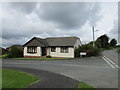
10
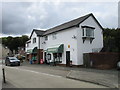
Village stores, Halwill Junction
With the demolition of the former station an attempt has been made to build a village centre on the site with the village stores, parish hall and public conveniences.
Image: © Jonathan Thacker
Taken: 18 Sep 2017
0.12 miles