IMAGES TAKEN NEAR TO
Halwill Junction, BEAWORTHY, EX21 5XD
Introduction
This page details the photographs taken nearby to EX21 5XD by members of the Geograph project.
The Geograph project started in 2005 with the aim of publishing, organising and preserving representative images for every square kilometre of Great Britain, Ireland and the Isle of Man.

There are currently over 7.5m images from over14,400 individuals and you can help contribute to the project by visiting https://www.geograph.org.uk
Image Map
Images are licensed for reuse under creativecommons.org/licenses/by-sa/2.0
Notes
- Clicking on the map will re-center to the selected point.
- The higher the marker number, the further away the image location is from the centre of the postcode.
Image Listing (7 Images Found)
Images are licensed for reuse under creativecommons.org/licenses/by-sa/2.0
Image
Details
Distance
2
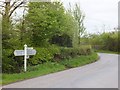
Signpost opposite Chilla Chapel
The junction is named on the upright as "Chilla Chapel"
Image: © David Smith
Taken: 11 May 2012
0.06 miles

4
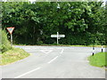
Signpost at road junction by Chilla Methodist Chapel
Image: © Dave Napier
Taken: 16 Jul 2008
0.06 miles
5
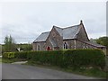
Chilla Chapel
Built as a Bible Christian Chapel, this is still used as a place of Methodist worship
Image: © David Smith
Taken: 11 May 2012
0.06 miles
6
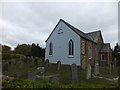
Chilla Chapel and burial ground
The inscription describes this as a Bible Christian Chapel; nowadays it is a Methodist chapel.
Image: © David Smith
Taken: 11 May 2012
0.06 miles
7
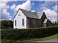
Chilla Methodist Church
Built in 1893 as a Bible Christian chapel at the junction of the lane from West Chilla (which runs along the side of the building) with the Highampton to Halwill Junction road.
Image: © Derek Harper
Taken: 7 Jul 2007
0.07 miles