IMAGES TAKEN NEAR TO
Halwill, BEAWORTHY, EX21 5UY
Introduction
This page details the photographs taken nearby to EX21 5UY by members of the Geograph project.
The Geograph project started in 2005 with the aim of publishing, organising and preserving representative images for every square kilometre of Great Britain, Ireland and the Isle of Man.

There are currently over 7.5m images from over14,400 individuals and you can help contribute to the project by visiting https://www.geograph.org.uk
Image Map
Images are licensed for reuse under creativecommons.org/licenses/by-sa/2.0
Notes
- Clicking on the map will re-center to the selected point.
- The higher the marker number, the further away the image location is from the centre of the postcode.
Image Listing (4 Images Found)
Images are licensed for reuse under creativecommons.org/licenses/by-sa/2.0
Image
Details
Distance
1

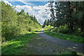
Halwill Moor Plantation
This forms part of Cookworthy Forest, which is how it is labelled on the adjacent sign beside this entrance off the A3079 about a kilometre west of Halwill Junction.
Image: © Derek Harper
Taken: 15 Jun 2007
0.06 miles
2

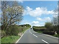
A3079 near Halwill Moor Plantation
Image: © Julian P Guffogg
Taken: 12 Aug 2013
0.09 miles
3
Bridge over a small stream near Caradon View
The stream is a tributary of the River Carey. Caradon View is the house on the left.
Image: © David Smith
Taken: 11 May 2012
0.13 miles