IMAGES TAKEN NEAR TO
Halwill, BEAWORTHY, EX21 5UG
Introduction
This page details the photographs taken nearby to EX21 5UG by members of the Geograph project.
The Geograph project started in 2005 with the aim of publishing, organising and preserving representative images for every square kilometre of Great Britain, Ireland and the Isle of Man.

There are currently over 7.5m images from over14,400 individuals and you can help contribute to the project by visiting https://www.geograph.org.uk
Image Map (Loading...)


Getting Data...Please wait
Leaflet Map data © OpenStreetMap
Images are licensed for reuse under creativecommons.org/licenses/by-sa/2.0
Notes
- Clicking on the map will re-center to the selected point.
- The higher the marker number, the further away the image location is from the centre of the postcode.
Image Listing (8 Images Found)
Images are licensed for reuse under creativecommons.org/licenses/by-sa/2.0
Image
Details
Distance
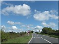
2
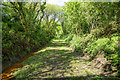
Trackbed of the Halwill to Launceston Branch
A bridleway now runs along this section of the dismantled railway.
Image: © Guy Wareham
Taken: 22 May 2016
0.17 miles
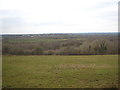
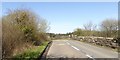
5
Once a bridge over the North Cornwall Railway
Looking towards Halwill junction no trains have passed under this bridge since October1966.
Image: © roger geach
Taken: 1 May 2012
0.19 miles
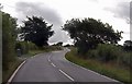
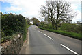
7
Former railway bridge on A3079 near Lane End
Now crossing the footpath that follows the railway track
Image: © David Smith
Taken: 18 Apr 2018
0.19 miles
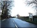
8
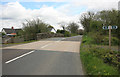
Warning signs on A3079
The A3079 has run in a straight line for several miles and now turns to cross a bridge over the former railway outside Halwill Junction
Image: © David Smith
Taken: 11 May 2012
0.22 miles