IMAGES TAKEN NEAR TO
Ashwater, BEAWORTHY, EX21 5DN
Introduction
This page details the photographs taken nearby to EX21 5DN by members of the Geograph project.
The Geograph project started in 2005 with the aim of publishing, organising and preserving representative images for every square kilometre of Great Britain, Ireland and the Isle of Man.

There are currently over 7.5m images from over14,400 individuals and you can help contribute to the project by visiting https://www.geograph.org.uk
Image Map
Images are licensed for reuse under creativecommons.org/licenses/by-sa/2.0
Notes
- Clicking on the map will re-center to the selected point.
- The higher the marker number, the further away the image location is from the centre of the postcode.
Image Listing (5 Images Found)
Images are licensed for reuse under creativecommons.org/licenses/by-sa/2.0
Image
Details
Distance
1
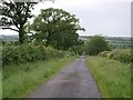
Lane below Hillside Cross
The straight lane with wide verges (drove-like qualities) descends to cross the River Claw.
Image: © Derek Harper
Taken: 15 Jun 2007
0.15 miles
2
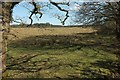
Little Claw Moor
Culm grassland seen from the lane shown in Image In the background is Southern Moor Plantation, access woodland.
Image: © Derek Harper
Taken: 23 Apr 2016
0.15 miles
3
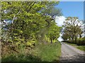
Road from Higher Claw Bridge to Hillside Cross
The road runs through woodland plantations on the western edge of a large area of forest.
Image: © David Smith
Taken: 11 May 2012
0.16 miles
4
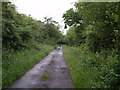
Lane crossing Little Claw Moor
The lane shown in Image crosses flat land approaching Higher Claw Bridge. This is poor agricultural land and woodland, much for conservation and recreational use, is the major land use.
Image: © Derek Harper
Taken: 15 Jun 2007
0.20 miles
5
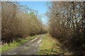
Lane crossing Little Claw Moor
Image: © Derek Harper
Taken: 23 Apr 2016
0.21 miles