IMAGES TAKEN NEAR TO
Lewdown, OKEHAMPTON, EX20 4PS
Introduction
This page details the photographs taken nearby to EX20 4PS by members of the Geograph project.
The Geograph project started in 2005 with the aim of publishing, organising and preserving representative images for every square kilometre of Great Britain, Ireland and the Isle of Man.

There are currently over 7.5m images from over14,400 individuals and you can help contribute to the project by visiting https://www.geograph.org.uk
Image Map (Loading...)


Getting Data...Please wait
Leaflet Map data © OpenStreetMap
Images are licensed for reuse under creativecommons.org/licenses/by-sa/2.0
Notes
- Clicking on the map will re-center to the selected point.
- The higher the marker number, the further away the image location is from the centre of the postcode.
Image Listing (21 Images Found)
Images are licensed for reuse under creativecommons.org/licenses/by-sa/2.0
Image
Details
Distance
1
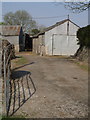
Barns at Thorn
See Image; this view is further to the right through the same gateway.
Image: © Derek Harper
Taken: 1 May 2007
0.01 miles
2
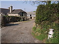
Thorn
The reassuring sight of a milk-churn by the entrance to this West Devon farm on the Stowford - Sydenham lane.
Image: © Derek Harper
Taken: 1 May 2007
0.01 miles
3
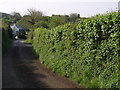
Lane to Thornlea
From outside the farm at Thorn, a view down the lane towards Thornlea, which is in SX4384.
Image: © Derek Harper
Taken: 1 May 2007
0.03 miles
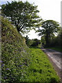
4
Lane near Thornlea
Thornlea (also seen in Image) is the cottage seen over the hedge. This is the lane from Sydneham to Stowford at the point where it is crossed by a track from Dippertown to Lewtrenchard.
Image: © Derek Harper
Taken: 1 May 2007
0.12 miles
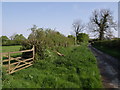
5
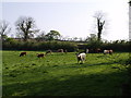
Cattle in a field
Specifically, the one shown in Image, and with the same gate visible. This view is from Marystow Footpath 10. The distant building in the centre must be recent, as it does not appear on any maps.
Image: © Derek Harper
Taken: 1 May 2007
0.13 miles
6
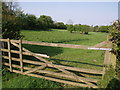
Field near Thorn
The isolated group of hawthorns in the middle of the field are all that remains of a field boundary shown on the maps. The gate can be recognised from Image
Image: © Derek Harper
Taken: 1 May 2007
0.13 miles
7
Lane from West Raddon
The lane leading from the farm approaches the Stowford - Sydenham lane.
Image: © Derek Harper
Taken: 1 May 2007
0.14 miles
8
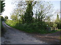
Lane and path near West Raddon
Marystow Footpath 10 heads off westwards on the right of the lane to Sydenham.
Image: © Derek Harper
Taken: 1 May 2007
0.14 miles
9
Laneside at West Raddon
The short no through lane leading to West Raddon approaches the eastern edge of the square.
Image: © Derek Harper
Taken: 1 May 2007
0.16 miles
10
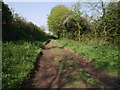
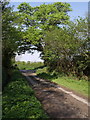
Marystow Footpath 10
The footpath is heading west towards Dippertown, a kilometre away.
Image: © Derek Harper
Taken: 1 May 2007
0.17 miles