IMAGES TAKEN NEAR TO
Lydford, OKEHAMPTON, EX20 4AL
Introduction
This page details the photographs taken nearby to EX20 4AL by members of the Geograph project.
The Geograph project started in 2005 with the aim of publishing, organising and preserving representative images for every square kilometre of Great Britain, Ireland and the Isle of Man.

There are currently over 7.5m images from over14,400 individuals and you can help contribute to the project by visiting https://www.geograph.org.uk
Image Map
Images are licensed for reuse under creativecommons.org/licenses/by-sa/2.0
Notes
- Clicking on the map will re-center to the selected point.
- The higher the marker number, the further away the image location is from the centre of the postcode.
Image Listing (13 Images Found)
Images are licensed for reuse under creativecommons.org/licenses/by-sa/2.0
Image
Details
Distance
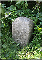
1
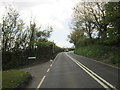
Old Milestone by the A386, Higher Beardon
Carved stone post by the A386, in parish of LYDFORD (WEST DEVON District), Higher Beardon, at entrance to Lychway track to Lydford, on grass verge in hedge under holly, on West side of access road to properties. Large Tavistock tombstone, erected by the Tavistock turnpike trust in the 18th century.
Inscription reads:-
From
Tavistock
7 - Miles
Oakhampton
8
Truro - 57
Scheduled Monument. List Entry Number:1003181
https://historicengland.org.uk/listing/the-list/list-entry/1003181
Milestone Society National ID: DV_TVOK07.
Image: © Alan Rosevear
Taken: 20 Apr 2011
0.10 miles
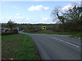
2
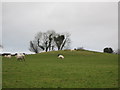
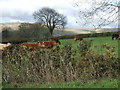
Sheep on a filled Shaft at Kitts Steps Mine
This mine was worked from 3 shafts in the mid 19th century for lead and silver. There is an open adit discharging into the river Lyd further down the hill side.
Image: © M Hunter
Taken: 21 Dec 2008
0.11 miles
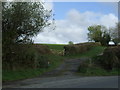
3
Boundary Marker by the A386, near Higher Beardon Farm
Turnpike Horse Marker - 'Take Off' stone, by the A386, in parish of Lydford (West Devon District), Higher Beardon Farm, 20m down towards Lychway path, on grass verge by side of pull-in under hedge. Erected by county Turnpike Trust in the 20th century.
Inscription reads:-
Take
off
Devon & Dartmoor HER.
HER Number: MDV72012 https://www.heritagegateway.org.uk/Gateway/Results_Single.aspx?uid=MDV72012&resourceID=104
Surveyed
Milestone Society National ID: DV_TVOK06hs
Image: © Alan Rosevear
Taken: 20 Apr 2011
0.11 miles