IMAGES TAKEN NEAR TO
Pearse Close, OKEHAMPTON, EX20 3QW
Introduction
This page details the photographs taken nearby to Pearse Close, EX20 3QW by members of the Geograph project.
The Geograph project started in 2005 with the aim of publishing, organising and preserving representative images for every square kilometre of Great Britain, Ireland and the Isle of Man.

There are currently over 7.5m images from over14,400 individuals and you can help contribute to the project by visiting https://www.geograph.org.uk
Image Map
Images are licensed for reuse under creativecommons.org/licenses/by-sa/2.0
Notes
- Clicking on the map will re-center to the selected point.
- The higher the marker number, the further away the image location is from the centre of the postcode.
Image Listing (18 Images Found)
Images are licensed for reuse under creativecommons.org/licenses/by-sa/2.0
Image
Details
Distance

2

Green bus shelter, A3072, Hatherleigh
This shelter serves an estate about half a mile from the centre of Hatherleigh; why paint it green?
Image: © David Smith
Taken: 14 Apr 2016
0.09 miles

4
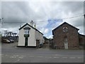
The Old Works and adjoining buildings
Including an electricity substation
Image: © David Smith
Taken: 21 Aug 2017
0.14 miles
5
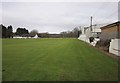
Hatherleigh Cricket Club
The view over the gate shown in Image "The club is one of the oldest in Devon and celebrated its centenary in 1988. The club moved to its present ground ... close to the River Lew, in the early 1950s. The present clubhouse was completed in 1986" http://www.hatherleighcc.co.uk/index2.php .
Image: © Derek Harper
Taken: 20 Feb 2012
0.14 miles
6

Protecting the cricketers from the spectators, or vice versa
Image: © David Smith
Taken: 21 Aug 2017
0.15 miles
7

Hatherleigh Cricket Club
This gate is by the A3072 to Holsworthy, but the entrance is now off to the right, from the same road that leads to the farm at Littlewood.
Image: © Derek Harper
Taken: 20 May 2007
0.17 miles
9

A386 skirting Hatherleigh
Also known as Bowling Green Lane.
Image: © Fernweh
Taken: 11 Jul 2014
0.19 miles
10
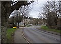
A3072 at Hatherleigh
The main road approaches the roundabout on the outskirts of Hatherleigh. Image is on the left here.
Image: © Derek Harper
Taken: 20 Feb 2012
0.19 miles