IMAGES TAKEN NEAR TO
Hatherleigh, OKEHAMPTON, EX20 3LQ
Introduction
This page details the photographs taken nearby to EX20 3LQ by members of the Geograph project.
The Geograph project started in 2005 with the aim of publishing, organising and preserving representative images for every square kilometre of Great Britain, Ireland and the Isle of Man.

There are currently over 7.5m images from over14,400 individuals and you can help contribute to the project by visiting https://www.geograph.org.uk
Image Map
Images are licensed for reuse under creativecommons.org/licenses/by-sa/2.0
Notes
- Clicking on the map will re-center to the selected point.
- The higher the marker number, the further away the image location is from the centre of the postcode.
Image Listing (7 Images Found)
Images are licensed for reuse under creativecommons.org/licenses/by-sa/2.0
Image
Details
Distance

4
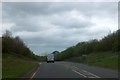
Hatherleigh by-pass turning for Fishleigh
Cycle track NCN3, the Devon coast-to-coast, crosses here, on the stage from Hatherleigh to Sheepwash
Image: © David Smith
Taken: 9 May 2013
0.13 miles
5

Hatherleigh: towards Strawbridge
Farmland north west of the town
Image: © Martin Bodman
Taken: 8 Feb 2006
0.16 miles
6

Old Milestone by the A386, Fishleigh Cross
Carved stone post by the A386, in parish of HATHERLEIGH (WEST DEVON District), North of Fishleigh Cross, on by-pass, 50m South of junction with old road, by path rising up the embankment, in low wall beside bridleway sign and path leading to town, on East side of road. Re-located during roadworks from further North by Stone Fishleigh Cottage. Torrington tombstone, erected by the Great Torrington turnpike trust in the 18th century.
Inscription reads:-
TO
TORRINGTON
11
MILES
Milestone Society National ID: DV_GTHA11
Image: © Alan Rosevear
Taken: 18 Feb 2013
0.18 miles
7
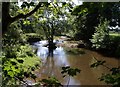
River Lew
The Lew, flowing towards the camera, seen from Hatherleigh Footpath 1. A tree, probably an alder, seems to have become marooned as an island.
Image: © Derek Harper
Taken: 23 Aug 2007
0.20 miles