IMAGES TAKEN NEAR TO
Hatherleigh, OKEHAMPTON, EX20 3LL
Introduction
This page details the photographs taken nearby to EX20 3LL by members of the Geograph project.
The Geograph project started in 2005 with the aim of publishing, organising and preserving representative images for every square kilometre of Great Britain, Ireland and the Isle of Man.

There are currently over 7.5m images from over14,400 individuals and you can help contribute to the project by visiting https://www.geograph.org.uk
Image Map
Images are licensed for reuse under creativecommons.org/licenses/by-sa/2.0
Notes
- Clicking on the map will re-center to the selected point.
- The higher the marker number, the further away the image location is from the centre of the postcode.
Image Listing (14 Images Found)
Images are licensed for reuse under creativecommons.org/licenses/by-sa/2.0
Image
Details
Distance
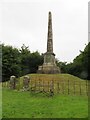
2
Obelisk, monument to the soldier William Morris
Image: © David Smith
Taken: 31 Dec 2007
0.11 miles
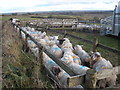
3
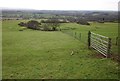
Hatherleigh Moor
From the road between Hatherleigh and Deckport Cross, looking across the western slopes of the moor.
Image: © Derek Harper
Taken: 20 Feb 2012
0.12 miles
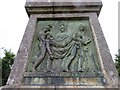
4
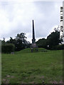
Monument To William Morris
William Morris was a Light Brigade Hero. He led the charge of the Light Brigade down the valley of death in Oct 1854 at the battle of Balaklava.
He had been in the Sikh Wars in India, and got Medals for gallantry at Sobraon and Aliwal.
One of England's forgotten heroes but he was never forgotten by the people of Devon.
Image: © John Douglas
Taken: 29 Jun 2007
0.16 miles
5

Old Wayside Cross at Stoning Cross, Hatherleigh
Hatherleigh Park Cross (Stoning), old head, shaft and base, by the UC road, in parish of Hatherleigh (West Devon District), Stoning Cross, East end of Park Road at junction with Victoria Road, on a bank below the signpost and telegraph pole.
Grade II listed.
List Entry Number: 1165724 https://historicengland.org.uk/listing/the-list/list-entry/1165724
Scheduled Monument.
List Entry Number: 1013715 https://historicengland.org.uk/listing/the-list/list-entry/1013715
Surveyed
Milestone Society National ID: DVWD_HAT02
Image: © Alan Rosevear
Taken: 19 Jun 2010
0.21 miles
6
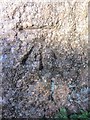
Ordnance Survey Cut Mark
This OS cut mark can be found on Hatherleigh Cross. It marks a point 122.119m above mean sea level. http://www.geograph.org.uk/photo/3860219
Image: © Adrian Dust
Taken: 18 Feb 2014
0.21 miles
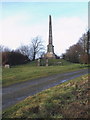
7

Hatherleigh Cross
There is an OS cut mark at the base. http://www.geograph.org.uk/photo/3860218
Image: © Adrian Dust
Taken: 18 Feb 2014
0.21 miles
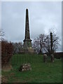
8
Monument, near Deckport Cross
Dedicated to a local officer, who fought in the Battle of Balaclava.
Image: © Roger Cornfoot
Taken: 24 Jan 2009
0.22 miles