IMAGES TAKEN NEAR TO
Northlew, OKEHAMPTON, EX20 3BS
Introduction
This page details the photographs taken nearby to EX20 3BS by members of the Geograph project.
The Geograph project started in 2005 with the aim of publishing, organising and preserving representative images for every square kilometre of Great Britain, Ireland and the Isle of Man.

There are currently over 7.5m images from over14,400 individuals and you can help contribute to the project by visiting https://www.geograph.org.uk
Image Map
Images are licensed for reuse under creativecommons.org/licenses/by-sa/2.0
Notes
- Clicking on the map will re-center to the selected point.
- The higher the marker number, the further away the image location is from the centre of the postcode.
Image Listing (13 Images Found)
Images are licensed for reuse under creativecommons.org/licenses/by-sa/2.0
Image
Details
Distance
1
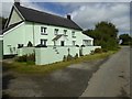
Durdon Cross Farm
A modern, miniature cross stands outside the front wall
Image: © David Smith
Taken: 21 Aug 2017
0.01 miles
2
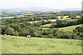
Inwardleigh: near Homing Down Cross
Looking south east towards Dartmoor
Image: © Martin Bodman
Taken: 8 Jul 2006
0.04 miles
3
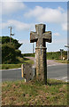
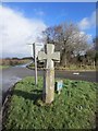
Old Wayside Cross - Durdon Cross by Waterhouse Hill, Northlew parish
Durdon Cross, old head, shaft and base, by the UC road, in parish of Northlew (West Devon District), Durdon Cross, junction with Waterhouse Hill, East of Northlew, on grass triangle at junction.
Grade II listed.
List Entry Number: 1308750 https://historicengland.org.uk/listing/the-list/list-entry/1308750
Scheduled Monument.
List Entry Number: 1013610 https://historicengland.org.uk/listing/the-list/list-entry/1013610
Surveyed
Milestone Society National ID: DVWD_NLW01
Image: © Milestone Society
Taken: Unknown
0.07 miles
4
Durdon Cross
At the junction of the road from Okehampton to Northlew with Waterhouse Hill on the far side, and a lane to Lambert Cross to the right of the camera. A pair of grass triangles. The granite wayside cross is described at http://www.dartmoor-crosses.org.uk/durdon.htm and briefly at http://www.britishlistedbuildings.co.uk/en-93324-durdon-cross-northlew .
Image: © Derek Harper
Taken: 20 Jan 2012
0.07 miles
5
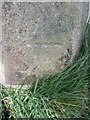
Ordnance Survey Cut Mark
This OS cut mark can be found on Durdon Cross. It marks a point 187.197m above mean sea level. http://www.geograph.org.uk/photo/3858486
Image: © Adrian Dust
Taken: 15 Feb 2014
0.07 miles
6
Durden Cross
There is an OS cut mark on the cross. http://www.geograph.org.uk/photo/3858478
Image: © Adrian Dust
Taken: 15 Feb 2014
0.07 miles
8
Durdon Cross
It stands at a crossroads; the cross has been restored, with an iron bar in the rear to hold it together. https://www.historicengland.org.uk/listing/the-list/list-entry/1013610
Image: © David Smith
Taken: 21 Aug 2017
0.08 miles
9
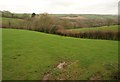
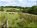
Pasture near Heath Moor
Image looks over the same area on a rather nicer day. This is from the lane south of Homing Down Cross towards Cruft.
Image: © Derek Harper
Taken: 20 Jan 2012
0.09 miles
10
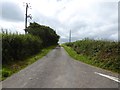
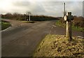
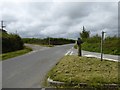
Road across Heath Moor to Waterhouse Hill
Image: © David Smith
Taken: 21 Aug 2017
0.13 miles