IMAGES TAKEN NEAR TO
Whiddon Down, OKEHAMPTON, EX20 2QP
Introduction
This page details the photographs taken nearby to EX20 2QP by members of the Geograph project.
The Geograph project started in 2005 with the aim of publishing, organising and preserving representative images for every square kilometre of Great Britain, Ireland and the Isle of Man.

There are currently over 7.5m images from over14,400 individuals and you can help contribute to the project by visiting https://www.geograph.org.uk
Image Map
Images are licensed for reuse under creativecommons.org/licenses/by-sa/2.0
Notes
- Clicking on the map will re-center to the selected point.
- The higher the marker number, the further away the image location is from the centre of the postcode.
Image Listing (46 Images Found)
Images are licensed for reuse under creativecommons.org/licenses/by-sa/2.0
Image
Details
Distance
1
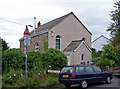
The Old Chapel
Now converted into a private house.
Image: © Richard Dorrell
Taken: 17 Jul 2008
0.02 miles
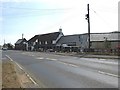
2

The Post Inn, Whiddon Down
Until 1964, named 'The Post Office Inn', having been one of a chain of roadside inns on which the history of the Post Office was founded. The building dates back to the 15th Century.
Image: © Richard Dorrell
Taken: 17 Jul 2008
0.03 miles
3
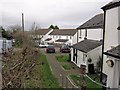
Housing in Turnpike Road
A small modern development in a minor road in Whiddon Down.
Image: © Richard Dorrell
Taken: 25 Jan 2015
0.04 miles
4
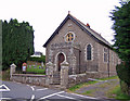
Methodist Chapel, Whiddon Down
Dated 1906.
Image: © Richard Dorrell
Taken: 17 Jul 2008
0.04 miles
5
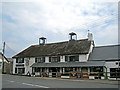
The Post Inn goes green
A couple of high tech wind turbines have recently appeared on the roof of the 15th century Post Inn, Whiddon Down. That'll cut the electricity bills then. But, shhh, don't tell anyone... they are not actually connected to anything yet. I have to agree this is a more attractive solution to green energy than a roof covered with solar PV panels, but will they ever generate as much power?
Image: © Richard Dorrell
Taken: 30 Jul 2011
0.04 miles
6

Cottage at Whiddon Down
This cottage is at the offset crossroads where the A3124 (behind the cottage) meets the main road, the A382. The turning on the right is Turnpike Road.
Image: © Derek Harper
Taken: 17 Oct 2009
0.04 miles
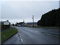

9
The road through Whiddon Down, looking towards the Post Inn
Image: © David Gearing
Taken: 22 Jul 2013
0.05 miles
10
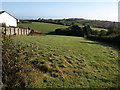
Meadow at Whiddon Down
This narrow strip is just the western corner of a quite large field from which bites have been taken to accommodate housing plots, for example the two on the left. On the right it is bordered by the Fingle Brook which has its source here. beyond the further house on the left it borders the A382.
Image: © Derek Harper
Taken: 17 Oct 2009
0.05 miles