IMAGES TAKEN NEAR TO
Livaton, OKEHAMPTON, EX20 2PP
Introduction
This page details the photographs taken nearby to Livaton, EX20 2PP by members of the Geograph project.
The Geograph project started in 2005 with the aim of publishing, organising and preserving representative images for every square kilometre of Great Britain, Ireland and the Isle of Man.

There are currently over 7.5m images from over14,400 individuals and you can help contribute to the project by visiting https://www.geograph.org.uk
Image Map
Images are licensed for reuse under creativecommons.org/licenses/by-sa/2.0
Notes
- Clicking on the map will re-center to the selected point.
- The higher the marker number, the further away the image location is from the centre of the postcode.
Image Listing (13 Images Found)
Images are licensed for reuse under creativecommons.org/licenses/by-sa/2.0
Image
Details
Distance
1

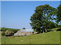
Holland Barn
Another view of Image from South Tawton Footpath 43, with cattle and sheep in the same field.
Image: © Derek Harper
Taken: 8 Jun 2006
0.02 miles
2
Holland Barn, Livaton
Beneath a cluster of beech trees. Taken from South Tawton Footpath 43 between Addiscott and Livaton.
Image: © Derek Harper
Taken: 8 Jun 2006
0.02 miles
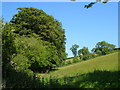
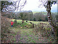
3

Pasture by Holland Barn
Cattle stare in amazement at someone walking South Tawton Footpath 43 alongside their field. The sheep with which they share it aren't bothered, but are too far off to notice. The pair of trees probably indicate where this field was once divided in two. According to the detailed maps, springs seem to surround this field (which adjoins Image), but it looks fairly dry in this hot weather. Image is just off to the right.
Image: © Derek Harper
Taken: 8 Jun 2006
0.07 miles
4
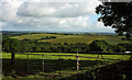
Near Dinnwell
A somewhat wider view than Image, and in pleasanter weather. The sizeable wood in the valley really ought to have a name, but the maps dpn't supply one. We are just inside the Dartmoor National Park; cross the lane behind the camera and we're not.
Image: © Derek Harper
Taken: 21 Jun 2019
0.12 miles
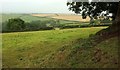
5
Fields below Dinnwell
This rectangular field of grass descends the steep hillside below Dinnwell to meet the green lane, from which this was taken, shown in Image
Image: © Derek Harper
Taken: 8 Jun 2006
0.13 miles
6
Farmland near Dinnwell
It's raining steadily here on the edge of the National Park. This is a view from the lane between Dinnwell and Livaton Cross.
Image: © Derek Harper
Taken: 21 Aug 2016
0.13 miles
7

Open woodland below Dinnwell
Really an overgrown meadow, beside the green lane shown in Image and with tiny streams running down both sides of it. This is fast becoming part of the area of woodland beyond, where these and other rivulets gather into a tributary of the Taw.
Image: © Derek Harper
Taken: 8 Jun 2006
0.14 miles
8
View north from Beaconpark Lane
Looking towards Livaton from the green lane which starts just west of Whiddon Down.
Image: © Richard Dorrell
Taken: 23 Mar 2010
0.17 miles
9

Green lane from Addiscott
Further east than Image, with the attractive banked lane, followed by South Tawton Footpath 43, approaching trees where it crosses a small tributary of the Taw.
Image: © Derek Harper
Taken: 8 Jun 2006
0.18 miles
10

Viewpoint near Dinnwell
Image: © Derek Harper
Taken: 21 Jun 2019
0.19 miles