IMAGES TAKEN NEAR TO
South Tawton, OKEHAMPTON, EX20 2LY
Introduction
This page details the photographs taken nearby to EX20 2LY by members of the Geograph project.
The Geograph project started in 2005 with the aim of publishing, organising and preserving representative images for every square kilometre of Great Britain, Ireland and the Isle of Man.

There are currently over 7.5m images from over14,400 individuals and you can help contribute to the project by visiting https://www.geograph.org.uk
Image Map
Images are licensed for reuse under creativecommons.org/licenses/by-sa/2.0
Notes
- Clicking on the map will re-center to the selected point.
- The higher the marker number, the further away the image location is from the centre of the postcode.
Image Listing (19 Images Found)
Images are licensed for reuse under creativecommons.org/licenses/by-sa/2.0
Image
Details
Distance
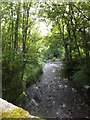
1
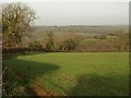
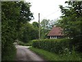
Field beside Wickington Lane
From a gateway on the lane, which carries South Tawton Footpath 60, and is on the other side of the hedge on the left, a view towards the Taw valley.
Image: © Derek Harper
Taken: 9 Dec 2009
0.08 miles
2
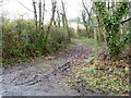
Footpath, Taw Green
The footpath takes walkers from Mill House to Wickington.
Image: © Maigheach-gheal
Taken: 15 Feb 2011
0.17 miles
3
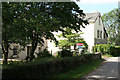
South Tawton: Taw Green
Mill House, left, and beyond The Mill, converted from a watermill. Its leat still functions. Looking north-north-west. The mill was advertised in 1886: ‘Taw Green Mills, South Tawton .. to be Let .. with immediate possession if required, driving three pairs of stones, patent Eureka smutter, flour machines .. Also Bake-House attached with large Oven, fitted with patent pyrometer, doing about eight sacks per week ..’ [The Western Times 2 March 1886]
Image: © Martin Bodman
Taken: 23 Jul 2006
0.19 miles
5
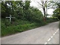
Taw Green Cross from the north
On the right is the former baptist chapel
Image: © David Smith
Taken: 27 May 2014
0.20 miles
6
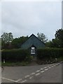
Former chapel at Taw Green
A "tin tabernacle" made of corrugated iron with the plaque "Taw Green Baptist Chapel 1903" now converted to be a house
Image: © David Smith
Taken: 27 May 2014
0.21 miles
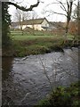
7
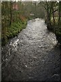
River Taw at Taw Green
Looking upstream from Image Through the trees on the left can be glimpsed the converted Baptist chapel at Taw Green.
Image: © Derek Harper
Taken: 9 Dec 2009
0.21 miles
8
The view upstream from Taw Green Bridge on the river Taw
Image: © Roger A Smith
Taken: 5 May 2010
0.21 miles
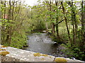
10
River Taw at Taw Green
From just east of the bridge at Taw Green; the river is flowing to the right. The fine farmhouse at Hayrish is listed http://www.imagesofengland.org.uk/Details/Default.aspx?id=93019&mode=adv .
Image: © Derek Harper
Taken: 9 Dec 2009
0.22 miles