IMAGES TAKEN NEAR TO
Ramsley, OKEHAMPTON, EX20 2LB
Introduction
This page details the photographs taken nearby to Ramsley, EX20 2LB by members of the Geograph project.
The Geograph project started in 2005 with the aim of publishing, organising and preserving representative images for every square kilometre of Great Britain, Ireland and the Isle of Man.

There are currently over 7.5m images from over14,400 individuals and you can help contribute to the project by visiting https://www.geograph.org.uk
Image Map
Images are licensed for reuse under creativecommons.org/licenses/by-sa/2.0
Notes
- Clicking on the map will re-center to the selected point.
- The higher the marker number, the further away the image location is from the centre of the postcode.
Image Listing (74 Images Found)
Images are licensed for reuse under creativecommons.org/licenses/by-sa/2.0
Image
Details
Distance
1
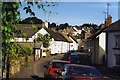
South Tawton: South Zeal
A borough was created here in 1299, providing for a market and two fairs. South Zeal was on the old road from Exeter to Okehampton. At the end of the 18th century the village was bypassed by the Okehampton turnpike, running to the south and skirting Dartmoor. Today this route, too, has been superseded by the dual-carriageway A30 opened in the 1980s.
Image: © Martin Bodman
Taken: Unknown
0.06 miles
2

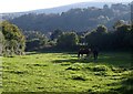
Footpath, South Zeal
South Tawton Footpath 1 crosses the southern part of the field shown in Image, where it widens behind the adjacent plot to the east.
Image: © Derek Harper
Taken: 27 Sep 2008
0.07 miles
3

Horse, South Zeal (2)
The horse from Image wants to make friends. But there's a walk to be undertaken before the sun goes down.
Image: © Derek Harper
Taken: 27 Sep 2008
0.08 miles
4
Horses, South Zeal
Very similar to Image, except that the horse has a pal.
Image: © Derek Harper
Taken: 27 Sep 2008
0.08 miles
5
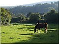
Horse, South Zeal
One of a pair of horses grazing in this long narrow field, typical of the way properties in South Zeal have linear plots behind them, and crossed by South Tawton Footpath 1.
Image: © Derek Harper
Taken: 27 Sep 2008
0.08 miles
6

Ramsley Lane
This lane lined with cottages runs beneath Ramsley Hill from the old A30 to the south-east end of South Zeal's village street.
Image: © Derek Harper
Taken: 27 Sep 2008
0.08 miles
7
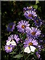
Butterflies and bee on Michaelmas daisies, South Zeal
The bee is harder to spot - on the second bloom from the top. These are by a lane, which doesn't seem to have a name, between the old A30 and Ramsley Lane.
Image: © Derek Harper
Taken: 27 Sep 2008
0.08 miles
8
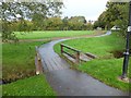
Footbridge over Shelley Brook
Alongside the present bridge are several granite slabs (an earlier bridge?). This is public open space in the village.
Image: © David Smith
Taken: 12 Oct 2011
0.09 miles
9

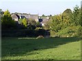
Paddock at South Zeal
The meadow is also shown in Image and Image Not the same animal, though. Roofs at South Zeal are in the background.
Image: © Derek Harper
Taken: 8 Jun 2006
0.10 miles
10
Paddock at South Zeal
South Tawton Footpaths 1 and 2 combine in this field to pass through the gate in the shadows and reach the scene in Image Image looks the other way.
Image: © Derek Harper
Taken: 27 Sep 2008
0.10 miles