
IMAGES TAKEN NEAR TO
South Zeal, OKEHAMPTON, EX20 2JX
Introduction
This page details the photographs taken nearby to EX20 2JX by members of the Geograph project.
The Geograph project started in 2005 with the aim of publishing, organising and preserving representative images for every square kilometre of Great Britain, Ireland and the Isle of Man.

There are currently over 7.5m images from over14,400 individuals and you can help contribute to the project by visiting https://www.geograph.org.uk
Image Map
Images are licensed for reuse under creativecommons.org/licenses/by-sa/2.0
Notes
- Clicking on the map will re-center to the selected point.
- The higher the marker number, the further away the image location is from the centre of the postcode.
Image Listing (67 Images Found)
Images are licensed for reuse under creativecommons.org/licenses/by-sa/2.0
Image
Details
Distance
1
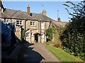
Footpath past cottages at South Zeal
South Tawton Footpath 1 runs past the rear of the cottages which front onto the main street of South Zeal.
Image: © Derek Harper
Taken: 27 Sep 2008
0.02 miles
2
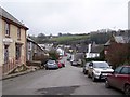
South Zeal
The lower end of the village, seen from just below St Mary's chapel.
The village stores is on the left, http://www.geograph.org.uk/photo/1092529 , and the Oxenham Arms pub on the right http://www.geograph.org.uk/photo/1092524 .
Image: © Richard Dorrell
Taken: 25 Dec 2008
0.02 miles
3

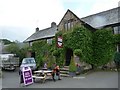
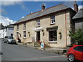
Oxenham Arms, South Zeal
Originally the manor house of the Burgoyne family.
The building was built in the late 16th century, and is upheld as a magnificent example of granite construction and domestic planning.
Image: © Richard Dorrell
Taken: 25 Dec 2008
0.03 miles
5
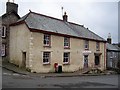
Village stores, South Zeal
Built in the late 16th or early 17th century.
The building has been the village stores for very many years.
Image: © Richard Dorrell
Taken: 25 Dec 2008
0.04 miles
6
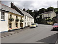
Main Street, South Zeal
The eastern end of the main street in South Zeal.
Image: © Tony Atkin
Taken: 2 Aug 2013
0.05 miles
7

Mounting block, Oxenham Arms
At the front of the hotel is a mounting block.
These steps were an important feature in the days when horses were the common mode of transport. The ladies with their long skirts would have had great difficulty in mounting their horses (even side-saddle) without the aid of these steps.
Image: © Maigheach-gheal
Taken: 15 Feb 2011
0.05 miles
9
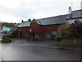
The Oxenham Arms Inn with autumn colour
Image: © David Smith
Taken: 12 Oct 2011
0.05 miles
10
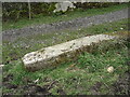
Old Boundary Marker in South Zeal village
Parish Boundary Marker lying as an edging stone beside the public footpath from South Zeal village through Mill Field towards Hillfield and Croft. South Tawton parish.
Inscribed D C / 4 (Duchy of Cornwall) and S Z / 4 (South Zeal citizens) on opposite faces. The stone is one of four stones (SZ1-SZ4) erected in 1895 on South Tawton Common by the Duchy of Cornwall to mark the boundary of their land and prevent encroachment on the Common by villagers, farmers and residents of the parish. The stone was originally located at SX654922, as evidenced by a conveyance held in the Devon Record Office by which the Duchy of Cornwall and 44 ‘purchasers’ legalised 108 enclosures of land which had been subject to dispute.
Milestone Society National ID: DV_SZ04pb
Image: © T Jenkinson
Taken: 21 Mar 2008
0.05 miles