IMAGES TAKEN NEAR TO
Bondleigh, NORTH TAWTON, EX20 2AP
Introduction
This page details the photographs taken nearby to EX20 2AP by members of the Geograph project.
The Geograph project started in 2005 with the aim of publishing, organising and preserving representative images for every square kilometre of Great Britain, Ireland and the Isle of Man.

There are currently over 7.5m images from over14,400 individuals and you can help contribute to the project by visiting https://www.geograph.org.uk
Image Map
Images are licensed for reuse under creativecommons.org/licenses/by-sa/2.0
Notes
- Clicking on the map will re-center to the selected point.
- The higher the marker number, the further away the image location is from the centre of the postcode.
Image Listing (4 Images Found)
Images are licensed for reuse under creativecommons.org/licenses/by-sa/2.0
Image
Details
Distance
1
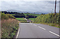
A3124 south from Cadditon Cross
The hills of Dartmoor in the distance.
Image: © J.Hannan-Briggs
Taken: 20 Jul 2017
0.08 miles
2
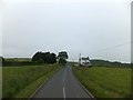
Moorview and Moorend by the A3124
The names of the farm and cottage are reminders that the area to the south is still called Honeychurch Moor, although much of the land is enclosed
Image: © David Smith
Taken: 21 Jun 2013
0.09 miles
3
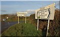
Cadditon Cross
Road signs at the crossroads. Image looks down the road to the right.
Image: © Derek Harper
Taken: 13 Jan 2012
0.24 miles
4
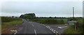
Cadditon Cross on A3124
Cadditon is a farm a short distance to the right. The name is also applied to the woodland ahead.
Image: © David Smith
Taken: 21 Jun 2013
0.24 miles