IMAGES TAKEN NEAR TO
Roborough, WINKLEIGH, EX19 8TD
Introduction
This page details the photographs taken nearby to EX19 8TD by members of the Geograph project.
The Geograph project started in 2005 with the aim of publishing, organising and preserving representative images for every square kilometre of Great Britain, Ireland and the Isle of Man.

There are currently over 7.5m images from over14,400 individuals and you can help contribute to the project by visiting https://www.geograph.org.uk
Image Map
Images are licensed for reuse under creativecommons.org/licenses/by-sa/2.0
Notes
- Clicking on the map will re-center to the selected point.
- The higher the marker number, the further away the image location is from the centre of the postcode.
Image Listing (3 Images Found)
Images are licensed for reuse under creativecommons.org/licenses/by-sa/2.0
Image
Details
Distance
2

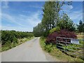
West Road
The ridgetop road eastwards from Roborough passes a small wood and the houses at High Field (centre) and Parkyns.
Image: © Derek Harper
Taken: 19 Apr 2013
0.19 miles
3
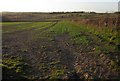
Countryside near Parkyns
The head of the valley that lies north of the Roborough ridge, seen from the road to Parkyns Cross. The indistinct farm on the central horizon is East Cliston.
Image: © Derek Harper
Taken: 19 Apr 2013
0.22 miles