1
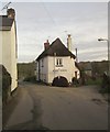
Monkokehampton post office, Devon
This could be Ireland, but is in fact deepest Devon.
Image: © nick macneill
Taken: 26 Mar 1995
0.04 miles
2
B3217 through Monkokehampton
Near to its junction with Duckport Cross (the road ahead, to the left).
Image: © John Baker
Taken: 26 Mar 2013
0.06 miles
3
Monkokehampton Methodist Chapel
Image: © David Smith
Taken: 10 Nov 2014
0.06 miles
4
Old circular AA sign on the former B3217 in Monkokehampton
Old AA Sign located on the wall of an old workshop, now a cottage called The Old Forge, on the east side of the former B3217 in Monkokehampton, 8 miles north of Okehampton. Monkokehampton parish.
This is the Circular, village name on black band, no Motor Union symbol or name type, dating from 1923, showing distances Okehampton 7½ Iddesleigh 2¼ London 196. Removed some time between July 2014 and August 2022.
There were five series of AA signs, mostly dating from 1923 and made by Francis & Co / Franco in Deptford, London. The village name and distance to London or Dublin were normally displayed.
See also https://www.flickr.com/photos/livesurfcams/14394800250 , https://www.flickr.com/photos/bumbishop/5656595 and https://www.flickr.com/photos/bridgemarkertim/3966823734.
Milestone Society National ID: DV-MONKO
Image: © A Rosevear
Taken: 24 Jun 2011
0.07 miles
5
Red barn, Monkokehampton, Devon
Image: © nick macneill
Taken: 26 Mar 1995
0.07 miles
6
Cottage, Monkokehampton
Occupying the corner between the B3217 (left) and the lane to Broadwoodkelly.
Image: © Derek Harper
Taken: 20 Feb 2012
0.08 miles
7
Village street, Monkokehampton
Farm buildings and a house west of the village centre. The lane leads to Hatherleigh.
Image: © Derek Harper
Taken: 20 Feb 2012
0.09 miles
8
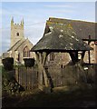
Lych Gate and Church, Monkokehampton
The C19 lych gate is described at http://www.britishlistedbuildings.co.uk/en-93316-lych-gate-approximately-35-metres-to-sout . Monkokehampton Footpath 2 passes through it and across the churchyard. See also
Image
Image: © Derek Harper
Taken: 20 Feb 2012
0.13 miles
9
Barn at Weirpark, Monkokehampton
Image: © David Smith
Taken: 10 Nov 2014
0.13 miles
10
Monkokehampton Mill
The last working water-powered corn mill in Devon, heritage and preserved mills aside. Built in the late 19th century, it stands by a leat from the Okement and was originally powered by two small overshot waterwheels. One survives in working order today.
Image: © Martin Bodman
Taken: 4 Sep 2004
0.13 miles


