IMAGES TAKEN NEAR TO
Beaford, WINKLEIGH, EX19 8NP
Introduction
This page details the photographs taken nearby to EX19 8NP by members of the Geograph project.
The Geograph project started in 2005 with the aim of publishing, organising and preserving representative images for every square kilometre of Great Britain, Ireland and the Isle of Man.

There are currently over 7.5m images from over14,400 individuals and you can help contribute to the project by visiting https://www.geograph.org.uk
Image Map (Loading...)


Getting Data...Please wait
Leaflet Map data © OpenStreetMap
Images are licensed for reuse under creativecommons.org/licenses/by-sa/2.0
Notes
- Clicking on the map will re-center to the selected point.
- The higher the marker number, the further away the image location is from the centre of the postcode.
Image Listing (6 Images Found)
Images are licensed for reuse under creativecommons.org/licenses/by-sa/2.0
Image
Details
Distance
1
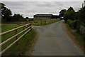
Farm buildings at Brealeys
A footpath follows the driveway on the left.
Image: © Philip Halling
Taken: 9 Sep 2007
0.05 miles
2
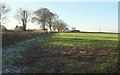
Farmland by the A3124
With Lane End Cottages. On the left, behind the hedge, is a track leading to them, but this isn't their principal access route.
Image: © Derek Harper
Taken: 30 Nov 2016
0.07 miles
3
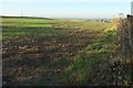
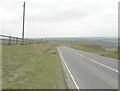
Field by the A3124
Looking right from where Image] was taken; the hedge and fence borders the main road, as shown in Image, although that was taken some 30 metres further along the road, by which time the hedge has faltered.
Image: © Derek Harper
Taken: 30 Nov 2016
0.16 miles
4
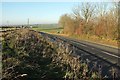
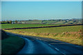
A3124 near Lantern Cross
About to begin a long descent into the Woolleigh Brook valley.
Image: © Derek Harper
Taken: 30 Nov 2016
0.18 miles
6
Beaford : The A3124
Heading through the parish of Beaford.
Image: © Lewis Clarke
Taken: 4 Dec 2019
0.24 miles