IMAGES TAKEN NEAR TO
Iddesleigh, WINKLEIGH, EX19 8BJ
Introduction
This page details the photographs taken nearby to EX19 8BJ by members of the Geograph project.
The Geograph project started in 2005 with the aim of publishing, organising and preserving representative images for every square kilometre of Great Britain, Ireland and the Isle of Man.

There are currently over 7.5m images from over14,400 individuals and you can help contribute to the project by visiting https://www.geograph.org.uk
Image Map
Images are licensed for reuse under creativecommons.org/licenses/by-sa/2.0
Notes
- Clicking on the map will re-center to the selected point.
- The higher the marker number, the further away the image location is from the centre of the postcode.
Image Listing (14 Images Found)
Images are licensed for reuse under creativecommons.org/licenses/by-sa/2.0
Image
Details
Distance
1

West doorway, Iddesleigh church
This doorway at the foot of the tower seen in Image has only a small portion of its leaf decoration remaining.
Image: © Derek Harper
Taken: 12 Jun 2007
0.07 miles
2
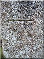
Ordnance Survey Cut Mark
This OS cut mark can be found on the Church of St James. It marks a point 109.700m above mean sea level.
Image: © Adrian Dust
Taken: 18 Feb 2014
0.07 miles
3

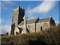
Iddesleigh church
The battlemented west tower of Image, seen from the corner of the churchyard.
Image: © Derek Harper
Taken: 12 Jun 2007
0.08 miles
5

Iddesleigh: St James? Church
The west tower of the 15th century structure stands on a raised churchyard
Image: © Martin Bodman
Taken: 8 Feb 2006
0.08 miles
6
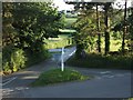
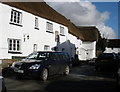
Iddesleigh Cross
The lane junction seen from the path at the edge of the churchyard. The main road is the B3217 which swings right around the raised churchyard here. The side lane goes to Iddesleigh Bridge.
Image: © Derek Harper
Taken: 12 Jun 2007
0.09 miles
7
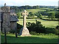
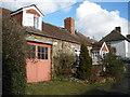
Cross in Iddesleigh churchyard
A cross in the southeast corner of the churchyard, with the Old Smithy on the left. Behind is the valley of a tributary of the Torridge; the hill is climbed by the Tarka Trail which also runs along the lane in front of the Smithy.
Image: © Derek Harper
Taken: 12 Jun 2007
0.09 miles
8
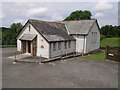
Iddesleigh Methodist chapel
The plaque states that this is the Bible Christian Chapel; the date is 1890. Mugs were produced in 1990 to commemorate the centenary. The chapel is situated at the junction of the B3217 and the lane to Loosedon Cross past Whitemoor. On the right is the gate to the cemetery.
Image: © Derek Harper
Taken: 28 Jun 2007
0.09 miles