IMAGES TAKEN NEAR TO
Chawleigh, CHULMLEIGH, EX18 7HR
Introduction
This page details the photographs taken nearby to EX18 7HR by members of the Geograph project.
The Geograph project started in 2005 with the aim of publishing, organising and preserving representative images for every square kilometre of Great Britain, Ireland and the Isle of Man.

There are currently over 7.5m images from over14,400 individuals and you can help contribute to the project by visiting https://www.geograph.org.uk
Image Map
Images are licensed for reuse under creativecommons.org/licenses/by-sa/2.0
Notes
- Clicking on the map will re-center to the selected point.
- The higher the marker number, the further away the image location is from the centre of the postcode.
Image Listing (7 Images Found)
Images are licensed for reuse under creativecommons.org/licenses/by-sa/2.0
Image
Details
Distance
2

Ordnance Survey Cut Mark
This OS cut mark can be found on the wall of Southcote Cottage. It marks a point 169.696m above mean sea level.
Image: © Adrian Dust
Taken: 13 Feb 2017
0.09 miles
3
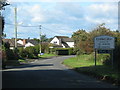
Chawleigh : B3042
Looking along the B3042.
Image: © Lewis Clarke
Taken: 30 Jan 2019
0.10 miles
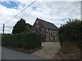
4
Former Methodist church, Chawleigh
The gable bears a plaque with the date 1822. But I think this building to the southeast of the village centre has been a private house for some time.
Image: © Derek Harper
Taken: 23 Mar 2011
0.13 miles
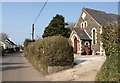
5
Former Methodist Church, Chawleigh
On the wall it is inscribed "Siloam 1822"
Image: © David Smith
Taken: 6 Aug 2013
0.14 miles