IMAGES TAKEN NEAR TO
Fore Street Hill, CHULMLEIGH, EX18 7BS
Introduction
This page details the photographs taken nearby to Fore Street Hill, EX18 7BS by members of the Geograph project.
The Geograph project started in 2005 with the aim of publishing, organising and preserving representative images for every square kilometre of Great Britain, Ireland and the Isle of Man.

There are currently over 7.5m images from over14,400 individuals and you can help contribute to the project by visiting https://www.geograph.org.uk
Image Map
Images are licensed for reuse under creativecommons.org/licenses/by-sa/2.0
Notes
- Clicking on the map will re-center to the selected point.
- The higher the marker number, the further away the image location is from the centre of the postcode.
Image Listing (132 Images Found)
Images are licensed for reuse under creativecommons.org/licenses/by-sa/2.0
Image
Details
Distance
1

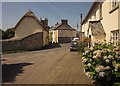
Road into Chulmleigh from Park Mill
Santa has arrived late on the first house; further along is an unusual balcony running the whole length of the frontage. It must give a view over the wall on the left and towards the valley.
Image: © David Smith
Taken: 2 Jan 2013
0.01 miles
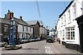
2
Junction, Chulmleigh
Fore Street is joined by the B3096, coming in from the left and turning into The Square. Ahead, New Street turns off towards the church. Every visible building is listed; on the left is the gable end of Hill View http://list.english-heritage.org.uk/resultsingle.aspx?uid=1325763&searchtype=mapsearch , while on the right, with the porch, is The Hill http://list.english-heritage.org.uk/resultsingle.aspx?uid=1325764&searchtype=mapsearch . Facing the camera between them is the former toll-house http://list.english-heritage.org.uk/resultsingle.aspx?uid=1106688&searchtype=mapsearch which "was used as a sorting office when Rainbow House" (the building next door with the large brick stack http://list.english-heritage.org.uk/resultsingle.aspx?uid=1106687&searchtype=mapsearch ) "operated as the town post office".
Image: © Derek Harper
Taken: 22 Aug 2013
0.02 miles
3
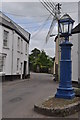
Chulmleigh : Egypt Lane
From the lamp in Fore Street, looking down Egypt Lane and out the village.
Image: © Lewis Clarke
Taken: 1 Jun 2011
0.03 miles
4
Chulmleigh: Look twice, it's a well disguised public convenience
Image: © Michael Garlick
Taken: 15 Apr 2018
0.04 miles
5
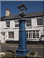
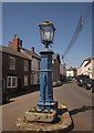
Pump, Chulmleigh
The town pump dates from the early C19 http://list.english-heritage.org.uk/resultsingle.aspx?uid=1304699&searchtype=mapsearch . See also Image and Image; "the glass lantern replac{es} an elaborate wrought iron name plaque which guided travellers to the {former Kings Arms} inn", which is in the background http://list.english-heritage.org.uk/resultsingle.aspx?uid=1106714&searchtype=mapsearch .
See also Image
Image: © Derek Harper
Taken: 22 Aug 2013
0.04 miles
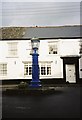
6
Pump, Chulmleigh
A view of Image from a different direction, with Fore Street (the B3096) in the background.
Image: © Derek Harper
Taken: 22 Aug 2013
0.04 miles

8
Chulmleigh: main street
The blue pillar on the left once formed part of the town’s water supply. Looking north west
Image: © Martin Bodman
Taken: 1 May 2007
0.05 miles
9
Chulmleigh: blue lamp
This lamp stands in the middle of the main road through Chulmleigh.
Image: © Chris Downer
Taken: 20 Nov 2001
0.05 miles
