IMAGES TAKEN NEAR TO
Langley View, CHULMLEIGH, EX18 7BQ
Introduction
This page details the photographs taken nearby to Langley View, EX18 7BQ by members of the Geograph project.
The Geograph project started in 2005 with the aim of publishing, organising and preserving representative images for every square kilometre of Great Britain, Ireland and the Isle of Man.

There are currently over 7.5m images from over14,400 individuals and you can help contribute to the project by visiting https://www.geograph.org.uk
Image Map
Images are licensed for reuse under creativecommons.org/licenses/by-sa/2.0
Notes
- Clicking on the map will re-center to the selected point.
- The higher the marker number, the further away the image location is from the centre of the postcode.
Image Listing (82 Images Found)
Images are licensed for reuse under creativecommons.org/licenses/by-sa/2.0
Image
Details
Distance
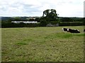
1
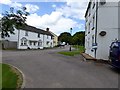
Houses in Langley, Chulmleigh
This modern development is on a site marked with a toy factory in the 1970s
Image: © David Smith
Taken: 7 Aug 2015
0.02 miles
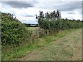
2
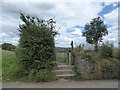
Steps to footpath and rugby field, Langley Lane, Chulmleigh
A public footpath leads from here to Parsonage Cross, avoiding a walk along the busy, narrow road
Image: © David Smith
Taken: 7 Aug 2015
0.04 miles
4
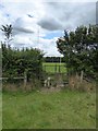
Stile and rugby posts, Chulmleigh
The end of the footpath from Parsonage Cross
Image: © David Smith
Taken: 7 Aug 2015
0.05 miles
5
Hedge and buildings east of Chulmleigh
Beyond the hedge is a building linked to the recreation ground. The stone building covered with ivy is not identified on the OS map, nor on older OS 1:2500 maps. It may be a lime kiln
Image: © David Smith
Taken: 7 Aug 2015
0.07 miles
6
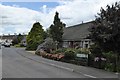
Beacon Rise, Chulmleigh
A cul-de-sac of modern houses and bungalows
Image: © David Smith
Taken: 7 Aug 2015
0.07 miles
7

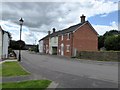
Chulmleigh : Primary School
Chulmleigh Primary School is situated in the small rural town of Chulmleigh, midway between Barnstaple and Exeter. It serves the town of Chulmleigh itself and the neighbouring village of Chawleigh.
Image: © Lewis Clarke
Taken: 15 Jun 2015
0.08 miles
8
Stile with a view of Chulmleigh houses
The path leads from here across a grassy field to the recreation ground, on the edge of the village, where the houses are found.
Image: © David Smith
Taken: 7 Aug 2015
0.13 miles
9

Chulmleigh : South Molton Street
South Molton Street in Chulmleigh which heads towards Chulmleigh Community College.
Image: © Lewis Clarke
Taken: 1 Jun 2011
0.13 miles
10
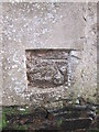
Ordnance Survey Cut Mark
This OS cut mark can be found on the wall of the garages/sheds north of Windmill Cottage, South Molton Street.
Image: © Adrian Dust
Taken: 28 Nov 2015
0.13 miles