IMAGES TAKEN NEAR TO
Black Dog, CREDITON, EX17 4QQ
Introduction
This page details the photographs taken nearby to EX17 4QQ by members of the Geograph project.
The Geograph project started in 2005 with the aim of publishing, organising and preserving representative images for every square kilometre of Great Britain, Ireland and the Isle of Man.

There are currently over 7.5m images from over14,400 individuals and you can help contribute to the project by visiting https://www.geograph.org.uk
Image Map
Images are licensed for reuse under creativecommons.org/licenses/by-sa/2.0
Notes
- Clicking on the map will re-center to the selected point.
- The higher the marker number, the further away the image location is from the centre of the postcode.
Image Listing (7 Images Found)
Images are licensed for reuse under creativecommons.org/licenses/by-sa/2.0
Image
Details
Distance
1
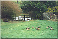
Ducks by the pond at Lewdon Farm
Image: © Sarah Charlesworth
Taken: 26 Dec 1991
0.06 miles
2
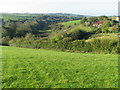
River Dalch valley at Lewdon Farm
This hidden section of the Dalch valley (north side) is a Devon Wildlife Site.
Image: © Jane Schofield
Taken: 23 Oct 2007
0.10 miles
4

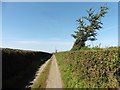
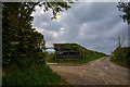
Farm track leading to Lewdon Farm, near Thelbridge
Grid square with public access only in the extreme north-east corner. The square contains the Dalch valley and Lewdon Farm.
Image: © Philip Halling
Taken: 16 Feb 2006
0.22 miles
6
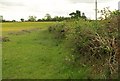
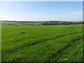
Field near Curriton
This is the field on the right of the lane shown in Image, looking in the opposite direction; the curiously-shaped conifer is at the end of Image The brushwood cuttings are presumably from the hedge.
Image: © Derek Harper
Taken: 12 May 2011
0.24 miles
7
Thelbridge : Country Lane
A lane to Lewdon Farm.
Image: © Lewis Clarke
Taken: 27 Apr 2020
0.24 miles