IMAGES TAKEN NEAR TO
Park View, CREDITON, EX17 4PF
Introduction
This page details the photographs taken nearby to Park View, EX17 4PF by members of the Geograph project.
The Geograph project started in 2005 with the aim of publishing, organising and preserving representative images for every square kilometre of Great Britain, Ireland and the Isle of Man.

There are currently over 7.5m images from over14,400 individuals and you can help contribute to the project by visiting https://www.geograph.org.uk
Image Map
Images are licensed for reuse under creativecommons.org/licenses/by-sa/2.0
Notes
- Clicking on the map will re-center to the selected point.
- The higher the marker number, the further away the image location is from the centre of the postcode.
Image Listing (30 Images Found)
Images are licensed for reuse under creativecommons.org/licenses/by-sa/2.0
Image
Details
Distance
1

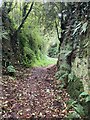
Green lane north of West Sandford
This green lane provides a pleasant path from West Sandford to the ridge road. The path is so far below the level of surrounding fields that it is hard to see the views. The path is still used to access fields.
Image: © David Smith
Taken: 25 Apr 2011
0.02 miles
2

West Sandford : Westdale
A house with a Mini parked outside of it.
Image: © Lewis Clarke
Taken: 6 Dec 2015
0.03 miles
3

West Sandford : Sandford Barton
An old looking barn in West Sandford.
Image: © Lewis Clarke
Taken: 6 Dec 2015
0.05 miles
4
Deep Lane at West Sandford
Deeply incised holloway, restricted byway Sandford 51 known as Deep Lane, rising from West Sandford towards the ridge road at the top.
Image: © Hugh Craddock
Taken: 20 Oct 2023
0.05 miles
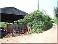
5
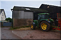
West Sandford : Sandford Barton
A tractor parking by the road at Sandford Barton.
Image: © Lewis Clarke
Taken: 6 Dec 2015
0.05 miles
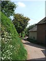
7

Road leading north-west from West Sandford
Image: © David Smith
Taken: 25 Apr 2011
0.09 miles
8
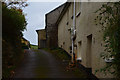
West Sandford : Hele Cottages
Hele Cottages and a small track heading alongside them.
Image: © Lewis Clarke
Taken: 6 Dec 2015
0.09 miles
10

Deep Lane
Deep Lane, a restricted byway (Sandford 51) from West Sandford north to the road from Jack Back's Cross to Ridgeway's Cross. Narrow but deeply incised at the Sandford end, where it climbs steeply out of the village.
Image: © Hugh Craddock
Taken: 20 Oct 2023
0.09 miles