IMAGES TAKEN NEAR TO
Sandford, CREDITON, EX17 4ED
Introduction
This page details the photographs taken nearby to EX17 4ED by members of the Geograph project.
The Geograph project started in 2005 with the aim of publishing, organising and preserving representative images for every square kilometre of Great Britain, Ireland and the Isle of Man.

There are currently over 7.5m images from over14,400 individuals and you can help contribute to the project by visiting https://www.geograph.org.uk
Image Map
Images are licensed for reuse under creativecommons.org/licenses/by-sa/2.0
Notes
- Clicking on the map will re-center to the selected point.
- The higher the marker number, the further away the image location is from the centre of the postcode.
Image Listing (18 Images Found)
Images are licensed for reuse under creativecommons.org/licenses/by-sa/2.0
Image
Details
Distance
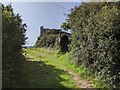
2
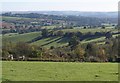
View over Sturridge
The view from the highest point on Sandford Footpath 17, with the roof and chimney of the farmhouse at Sturridge just discernible at near centre. The field boundary with trees casting their shadows down a combe is in Image Beyond is the Creedy valley, with Lower Creedy in Image
Image: © Derek Harper
Taken: 25 Oct 2010
0.02 miles
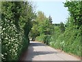
3
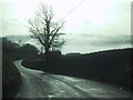
Road drops towards Sandford and a misty valley
Image: © Sarah Charlesworth
Taken: 9 Dec 2009
0.03 miles
5
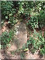
Milestone north of Sandford
The milestone reads "10 miles to Exeter". As the next town is Crediton, one wonders why the distance to Exeter was recorded.
Image: © David Smith
Taken: 25 Apr 2011
0.04 miles
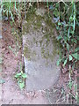
6
Road north of Sandford
There is a milestone "10 miles to Exeter" in the grass on the right hand bank of the road. Image]
Image: © David Smith
Taken: 25 Apr 2011
0.04 miles
7
Old Milestone north of Sandford
Carved stone post by the UC road, in parish of SANDFORD (MID DEVON District), 30m South of Sturridge & Hare House, 600m North of Orchard Close, buried in side bank, under vegetation, on East side of road. Exeter tombstone, erected by the Exeter turnpike trust in the 19th century.
Inscription reads:-
10
MILES
TO
EXETER
Milestone Society National ID: DV_EXSM10.
Image: © T Jenkinson
Taken: 17 Feb 2009
0.05 miles
9
Public footpath starting from a farm track
Image: © Rob Purvis
Taken: 18 Sep 2020
0.10 miles
10
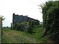
Barn and stile north of Sandford
The stile is little used; most walkers follow the farm track on the other side of the barn, which avoids the stile and patches of nettles.
Image: © David Smith
Taken: 25 Apr 2011
0.13 miles