IMAGES TAKEN NEAR TO
Stoodleigh, TIVERTON, EX16 9RT
Introduction
This page details the photographs taken nearby to EX16 9RT by members of the Geograph project.
The Geograph project started in 2005 with the aim of publishing, organising and preserving representative images for every square kilometre of Great Britain, Ireland and the Isle of Man.

There are currently over 7.5m images from over14,400 individuals and you can help contribute to the project by visiting https://www.geograph.org.uk
Image Map (4 Images)


Getting Data...Please wait
Leaflet Map data © OpenStreetMap
Images are licensed for reuse under creativecommons.org/licenses/by-sa/2.0
Notes
- Clicking on the map will re-center to the selected point.
- The higher the marker number, the further away the image location is from the centre of the postcode.
Image Listing (4 Images Found)
Images are licensed for reuse under creativecommons.org/licenses/by-sa/2.0
Image
Details
Distance
1
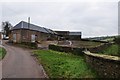
Mid Devon : Rifton Barton
The farm at the end of Rifton Lane at Rifton Barton in Mid Devon.
Image: © Lewis Clarke
Taken: 7 Jan 2013
0.07 miles
2
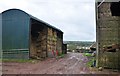
Mid Devon : Rifton Barton
A barn at the farm called Rifton Barton with hay being stored here.
Image: © Lewis Clarke
Taken: 7 Jan 2013
0.11 miles
3
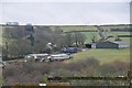
Mid Devon : Countryside & Diptford Farm
The countryside looking towards Diptford Farm which can be seen in view here.
Image: © Lewis Clarke
Taken: 7 Jan 2013
0.13 miles
4
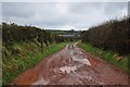
Mid Devon : Rifton Lane
Rifton Lane turns into a muddy track past Rifton Barton.
Image: © Lewis Clarke
Taken: 7 Jan 2013
0.22 miles