IMAGES TAKEN NEAR TO
Stoodleigh, TIVERTON, EX16 9PW
Introduction
This page details the photographs taken nearby to EX16 9PW by members of the Geograph project.
The Geograph project started in 2005 with the aim of publishing, organising and preserving representative images for every square kilometre of Great Britain, Ireland and the Isle of Man.

There are currently over 7.5m images from over14,400 individuals and you can help contribute to the project by visiting https://www.geograph.org.uk
Image Map
Images are licensed for reuse under creativecommons.org/licenses/by-sa/2.0
Notes
- Clicking on the map will re-center to the selected point.
- The higher the marker number, the further away the image location is from the centre of the postcode.
Image Listing (18 Images Found)
Images are licensed for reuse under creativecommons.org/licenses/by-sa/2.0
Image
Details
Distance

2
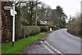
Stoodleigh : Ford Cross
Ford Cross at the junction with directions to Rull, Stoodleigh and Washfield.
Image: © Lewis Clarke
Taken: 7 Jan 2013
0.04 miles
3
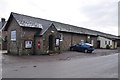
Stoodleigh : Village Hall
The Stoodleigh Village Hall with one car parked outside - wonder whose it could be...
Image: © Lewis Clarke
Taken: 7 Jan 2013
0.06 miles
4
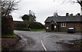
Stoodleigh : Road & Village Hall
A road heading into Stoodleigh with the Parish Hall in view.
Image: © Lewis Clarke
Taken: 7 Jan 2013
0.06 miles

6
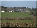
Ford Barton farm
A view across the shallow valley from a minor road
Image: © David Smith
Taken: 30 Mar 2012
0.09 miles
7
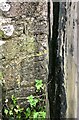
Cut Mark: Stoodleigh, Ford Barton
This is a cut benchmark, 0.7m above the ground and 242.32m above Ordnance Datum Newlyn (Tide Gauge Bolt Newlyn Pier - the authoritative datum for the UK). It was last verified in 1968. Grid ref: SS 9126 1844.
Image: © Ninjading
Taken: 1 Oct 2020
0.09 miles
8
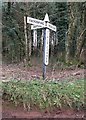
Old Direction Sign - Signpost by Vials Corner, Stoodleigh
Pyramidal cone finial - 3 arms; Devon I-post by the UC road, in parish of Stoodleigh (Mid Devon District), Vials Corner Y-junction, West of Stoodleigh village, under trees.
Surveyed
Milestone Society National ID: DV_SS9118C
Image: © Alan Rosevear
Taken: 4 Feb 2013
0.09 miles
9
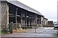
Stoodleigh : Ford Barton Farm
Looking into the barn and farmyard at Ford Barton.
Image: © Lewis Clarke
Taken: 7 Jan 2013
0.09 miles
10
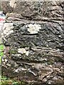
Cut Mark: Stoodleigh, Vials Corner
This is a cut benchmark, 0.5m above the ground and 247.89m above Ordnance Datum Newlyn (Tide Gauge Bolt Newlyn Pier - the authoritative datum for the UK). It was last verified in 1968. Grid ref: SS 9152 1855.
Image: © Ninjading
Taken: 1 Oct 2020
0.10 miles