IMAGES TAKEN NEAR TO
Oakford, TIVERTON, EX16 9EX
Introduction
This page details the photographs taken nearby to EX16 9EX by members of the Geograph project.
The Geograph project started in 2005 with the aim of publishing, organising and preserving representative images for every square kilometre of Great Britain, Ireland and the Isle of Man.

There are currently over 7.5m images from over14,400 individuals and you can help contribute to the project by visiting https://www.geograph.org.uk
Image Map
Images are licensed for reuse under creativecommons.org/licenses/by-sa/2.0
Notes
- Clicking on the map will re-center to the selected point.
- The higher the marker number, the further away the image location is from the centre of the postcode.
Image Listing (17 Images Found)
Images are licensed for reuse under creativecommons.org/licenses/by-sa/2.0
Image
Details
Distance
1
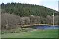
Mid Devon : Lake at Trout Fishery
As part of Bellbrook View Trout Fishery off of Aldridge Mill Hill lane.
Image: © Lewis Clarke
Taken: 7 Mar 2012
0.02 miles
2
Mid Devon : Bellbrook Valley Trout Fishery
Established for over 30 years Bellbrook has always been known for fly-fishing and trout fishing.
Image: © Lewis Clarke
Taken: 7 Mar 2012
0.03 miles
3
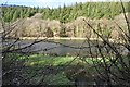
Mid Devon : Lake at Trout Fishery
A lake which is part of Bellbrook Valley Trout Fishery near Oakford.
Image: © Lewis Clarke
Taken: 7 Mar 2012
0.04 miles
4
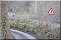
Mid Devon : Aldridge Mill Hill
A road known as Aldridge Mill Hill with a sign warning of pedestrians on the road as you approach the fish farm.
Image: © Lewis Clarke
Taken: 7 Mar 2012
0.10 miles
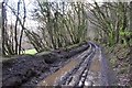
5
Track, Coleford Bottom
A route with public access that leads along the west side of Coleford Bottom, and beginning here along the east edge of Little Wood.
Image: © Derek Harper
Taken: 15 May 2013
0.14 miles
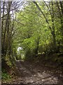
6
Mid Devon : Muddy Track through Little Wood
A muddy track through Little Wood which is also a public footpath.
Image: © Lewis Clarke
Taken: 7 Mar 2012
0.17 miles
7
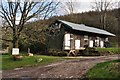
Stoodleigh: Aldridge Mill
The watermill is thought to be the structure standing to the left, behind the miller’s house. There was a farm or smallholding here as well, judging by the adjoining barns. Looking east
Image: © Martin Bodman
Taken: 15 Jun 2006
0.20 miles
8
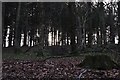
Mid Devon : Little Wood
Looking up towards the woodlands near Aldridge Mill Farm.
Image: © Lewis Clarke
Taken: 7 Mar 2012
0.21 miles
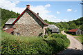
9
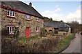
Mid Devon : Aldridge Mill Farm
Circa early to mid C19. Stone rubble; slate roof, gabled at ends; end stacks with brick shafts. It was formerly a mill but the machinery no longer exists. Forms a good group on the roadside with the adjacent farmbuildings.
Image: © Lewis Clarke
Taken: 7 Mar 2012
0.21 miles
10
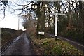
Mid Devon : Road & Signpost
Roads leading to the fishery and up towards Stoodleigh or Rackenford.
Image: © Lewis Clarke
Taken: 7 Mar 2012
0.22 miles