IMAGES TAKEN NEAR TO
Cadeleigh, TIVERTON, EX16 8HJ
Introduction
This page details the photographs taken nearby to EX16 8HJ by members of the Geograph project.
The Geograph project started in 2005 with the aim of publishing, organising and preserving representative images for every square kilometre of Great Britain, Ireland and the Isle of Man.

There are currently over 7.5m images from over14,400 individuals and you can help contribute to the project by visiting https://www.geograph.org.uk
Image Map
Images are licensed for reuse under creativecommons.org/licenses/by-sa/2.0
Notes
- Clicking on the map will re-center to the selected point.
- The higher the marker number, the further away the image location is from the centre of the postcode.
Image Listing (26 Images Found)
Images are licensed for reuse under creativecommons.org/licenses/by-sa/2.0
Image
Details
Distance
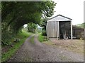
1
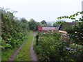
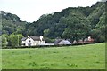
Ashliford farm buildings
The bridleway passes the farm and continues to Cadeleigh
Image: © David Smith
Taken: 19 Sep 2011
0.04 miles
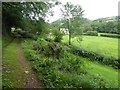
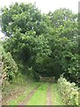
2
Path south-east of Ashilford
Running through woodland on the hillside beside the River Dart. The roof of Ashilford is on the right
Image: © David Smith
Taken: 17 Aug 2017
0.04 miles
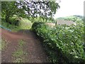
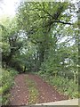
4
Bridleway south of Ashliford, on the way to Cadeleigh
The bridleway passes through woodland on the side of the valley of the River Dart
Image: © David Smith
Taken: 19 Sep 2011
0.05 miles
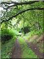
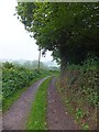
7
Bridleway entering woodland south of Ashliford
Image: © David Smith
Taken: 19 Sep 2011
0.16 miles
9
Mid Devon : Grassy Field
A grassy field with a view in the direction of Ashilford.
Image: © Lewis Clarke
Taken: 18 Sep 2013
0.17 miles
10
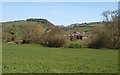
West Barton Farm
The farm comes complete with castellated tower, which I think is modern. This must be taken from the same point on Cadeleigh Bridleway 4 as Image On the left is Dart Bridge, site of an incident in September 2008 when the Dart burst its banks and a lorry was trapped in four feet of water. On the hill is Oldridge Wood.
Image: © Derek Harper
Taken: 22 Apr 2010
0.17 miles