IMAGES TAKEN NEAR TO
Burlescombe, TIVERTON, EX16 7LD
Introduction
This page details the photographs taken nearby to EX16 7LD by members of the Geograph project.
The Geograph project started in 2005 with the aim of publishing, organising and preserving representative images for every square kilometre of Great Britain, Ireland and the Isle of Man.

There are currently over 7.5m images from over14,400 individuals and you can help contribute to the project by visiting https://www.geograph.org.uk
Image Map
Images are licensed for reuse under creativecommons.org/licenses/by-sa/2.0
Notes
- Clicking on the map will re-center to the selected point.
- The higher the marker number, the further away the image location is from the centre of the postcode.
Image Listing (12 Images Found)
Images are licensed for reuse under creativecommons.org/licenses/by-sa/2.0
Image
Details
Distance
1
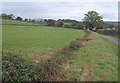
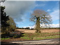
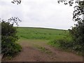
Towards Penslade
From roughly the same place as Image, looking across a field by the lane between Appledore and Penslade, which here carries the parish boundary between Burlesombe and Uffculme (right).
Image: © Derek Harper
Taken: 22 Oct 2010
0.05 miles
2
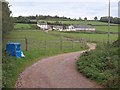
Burlescombe: near Penslade Farm
The lane in the foreground leads to Southdown Cross. Looking east-north-east
Image: © Martin Bodman
Taken: 13 Apr 2006
0.09 miles
5

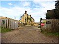
Farm buildings north-east of Appledore
Seen from beside the A38.
Image: © Robin Stott
Taken: 13 Dec 2009
0.17 miles
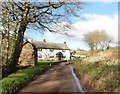
6
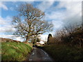
Lower Elms
The farm seen up a curving drive from the lane between Appledore and Penslade.
Image: © Derek Harper
Taken: 22 Oct 2010
0.17 miles
7
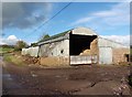
Corrugated iron barn at Escotts Farm
Image: © Roger Cornfoot
Taken: 10 Feb 2016
0.19 miles
9
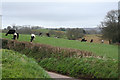
Field east of Appledore
A field without a gate at a bend in the road to Higher Cross
Image: © David Smith
Taken: 17 Oct 2015
0.23 miles