
IMAGES TAKEN NEAR TO
Burlescombe, TIVERTON, EX16 7FN
Introduction
This page details the photographs taken nearby to EX16 7FN by members of the Geograph project.
The Geograph project started in 2005 with the aim of publishing, organising and preserving representative images for every square kilometre of Great Britain, Ireland and the Isle of Man.

There are currently over 7.5m images from over14,400 individuals and you can help contribute to the project by visiting https://www.geograph.org.uk
Image Map
Images are licensed for reuse under creativecommons.org/licenses/by-sa/2.0
Notes
- Clicking on the map will re-center to the selected point.
- The higher the marker number, the further away the image location is from the centre of the postcode.
Image Listing (54 Images Found)
Images are licensed for reuse under creativecommons.org/licenses/by-sa/2.0
Image
Details
Distance
1

Mid Devon : Burlescombe Scenery
Looking towards the village of Burlescombe in Mid Devon with the church on the hill.
Image: © Lewis Clarke
Taken: 19 Feb 2012
0.03 miles


5
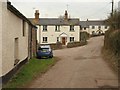
Cottages in Burlescombe
The village is built on a hillside above the valley of the River Lyner. This lane, arriving from the south, meets the C102, the equivalent of the main road, just past the furthest cottage. On the immediate left is a wall of The Barton, one of several farms along the lane.
Image: © Derek Harper
Taken: 3 Mar 2010
0.11 miles
6
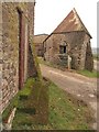
Barn at Burlescombe
An interestingly shaped barn at The Barton, seen from the junction shown in Image
Image: © Derek Harper
Taken: 3 Mar 2010
0.12 miles
7

Burlescombe : Mid Devon Scenery
Looking out across the Mid Devon countryside from Burlescombe.
Image: © Lewis Clarke
Taken: 8 Jul 2012
0.13 miles
8
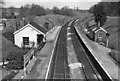
Burlescombe
View NE, towards Taunton etc.; ex-Great Western London/Bristol etc. - Taunton - Exeter - Plymouth - Penzance main line. This station was closed 5/10/64, to allow freer running for fast trains. Note the wide spacing between the platforms, a legacy of Brunel's Broad Gauge.
Image: © Ben Brooksbank
Taken: 22 Apr 1963
0.13 miles
9

Burlescombe : Grassy Field & Cattle
Taken from the car park beside the parish church in Burlescombe looking out over Mid Devon.
Image: © Lewis Clarke
Taken: 8 Jul 2012
0.13 miles
10
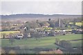
Mid Devon : Burlescombe Scenery
Looking across to the village of Burlescombe from a country road.
Image: © Lewis Clarke
Taken: 19 Feb 2012
0.13 miles